***
SOLD ***
Big Sandy Ranch
Mohave County, Arizona
Pictures
Please click on any of the pictures
for a larger view
|
|
|
|
|
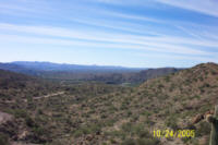
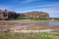
[1]
Big Sandy River near the northeast boundary of ranch
|
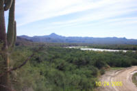
[2]
Deeded land along the Big Sandy River
|
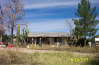
[3]
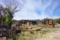
Ranch house
|
|
|
|
|
|
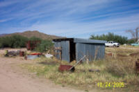
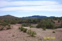
[4]
Tack shed
|
[5]
Corrals at headquarters
|
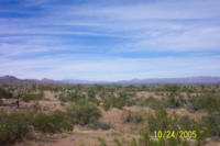
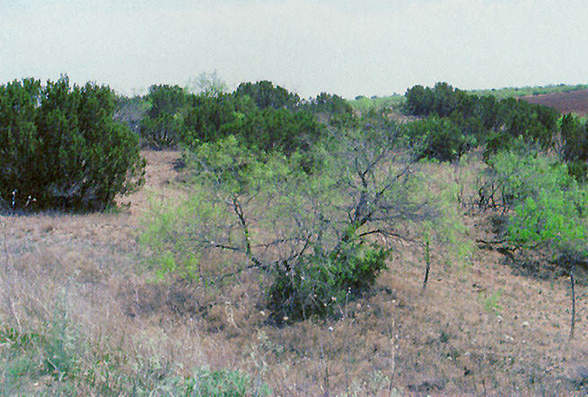
[6]
Typical rangeland on Northern portion of ranch
|
|
|
|
|
|
[7]
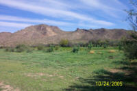
Irrigated pasture at headquarters
|
[8]
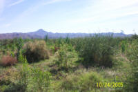
Abandoned irrigated pasture
|
[9]
Big Sandy River road crossing
|
|
|
|
|
|
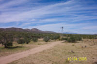
[10]
Baker windmill
|
[11]
Typical rangeland on Western portion of ranch
|
[12]
Misery windmill
|
Location
& Maps
Please click on any of the maps
for a larger view
|
|
|
|
|
|
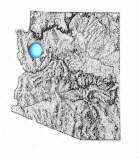
General
location in Arizona
|
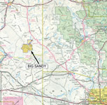
Location
map
|
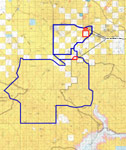
Topo
of the ranch
(Large map: ~600KB)
|
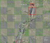
Aerial
map of the deeded land
|
Location
& Access
The ranch is located in southern Mohave County, in the western portion
of Arizona. The ranch is approximately 60 miles south of Kingman and
60 miles northwest of Wickenburg, Arizona. US Highway 93 provides
paved access from Kingman or Wickenburg to Signal Road. Signal Road
provides 5 miles of gravel access from the highway to the ranch headquarters
on the Big Sandy River. The headquarter site is located on the Big
Sandy River just above the Burro Creek confluence. The grazing allotment
generally lies between the Aubrey Peak Wilderness and the Arrastra
Mountain Wilderness with the Big Sandy River running from north to
south through the ranch.
Land Tenure
937 Acres Deeded
81,000 Acres Bureau of Land Management Allotment (approximate)
81,937 Acres Total or 128 Sections
Legal Description
Township 14 North Range 13 West
Gila and Salt River Baseline and Meridian
Section 12: portion thereof
Section 13: All
Township 13 North
Range 13 West
Gila and Salt River Baseline and Meridian
Section 3: portion thereof
Mohave County APN's:
102-21-007, 102-59-004 & 102-73-001
Bureau of Land Management Artillery Allotment
Property Description
The ranch headquarters is situated along the Big Sandy River just off
Signal Road near the northern boundary of the ranch. The building improvements
consist of an old, rustic, ranch house approximately 1,200 square feet
with 3 bedrooms and one bathroom (please see photo [3]
above) and a metal sided tack shed. There are three holding pens constructed
of wire and wooden post.
There is an irrigated
and sub-irrigated pasture at the headquarters. Historically the ranch
has irrigated up to 300-acres. More recently, 80-acres have been irrigated
and currently there are approximately 3-acres in permanent Bermuda Grass
pasture. The older fields have grown in with mesquite tress which could
be cleared and put back into production.
Water
Irrigation water is supplied by a diversionary right from the Big Sandy
River. The water is diverted using a temporary earthen dam into a dirt
ditch, then transported to the fields. This is a surface diversionary
water right on file with the Arizona Department of Water Resources as
#36-19867. Supplemental irrigation water is supplied by a 100 foot deep
well with production capability of 700 gallons per minute. The well
is not currently in operation.
Domestic water
is supplied by a private well with an electric submersible pump and
pressure tank. Livestock water on the ranch is supplied by the Big Sandy
River, 4 windmills, 4 solar wells and 4 earthen tanks.
Carrying Capacity
The capacity as recommended by the Bureau of Land Management is for
140 animal units on a yearlong basis. The annual operating plan may
differ from year to year based on annual rainfall and available forage.
Topography
Elevation at the headquarters is 1,550 feet and varies throughout the
ranch from 1,300 feet along the Big Sandy River near the southern boundary
to 3,500 feet in the McCracken Mountains. Topography is mostly rolling
hills with numerous drainage areas, with some steep mountain peaks in
the southern portion of the ranch.
Vegetation
Vegetation is primarily tobosa,
curly mesquite, galleta,
alfileria, indian wheat, squirrel
tail, and various grama
grasses. Browses are mesquite,
catclaw, jojoba,
mountain mahogany, cliffrose,
oakbrush, and winterfat.
Utilities
Public
electricity is available at the ranch headquarters; telephone is by
cell only.
Taxes
2005 Tax Year $307.44
2005 BLM Lease Grazing Fee $1.79 per animal unit month
Remarks
The ranch is located in an area rich with mining history and encompasses
the historic ghost town of Signal, which once had a population near
20,000 people. This is a beautiful, Mohave
Desert, working cattle ranch, with 15 miles of the Big Sandy River
running through the allotment.
Price
$1,650,000
Terms
Cash
Printable
Brochure
 Please click here to download (about 1.5
MB) a printable brochure in Adobe Acrobat format. If you get frustrated
trying to make this work on your computer, don't hesitate to ask us
to mail you a printed and bound brochure instead.
Please click here to download (about 1.5
MB) a printable brochure in Adobe Acrobat format. If you get frustrated
trying to make this work on your computer, don't hesitate to ask us
to mail you a printed and bound brochure instead.
Contact
Offered
for sale exclusively by:
Traegen H. Knight
Headquarters West, Ltd.
PO BOX 1980
St. Johns, AZ 85936
Phone: (928) 524-3740, Fax: (928) 563-7004, Cell: (602) 228-3494
Email: info@headquarterswest.com
Web: www.headquarterswest.com/bigsandy
See
Also
Also being handled
by Traegen Knight:
- Sold - Goodwater
Ranch
- 56,158 acres in Navajo County
Big
Hollow Ranch
- 19,409 acres in Apache County
- Sold - Greens
Peak Ranch
- 17,938 acres in Apache County
Disclaimer:
This information was obtained from sources deemed to be reliable but
is not guaranteed by the Broker. Prospective buyers should check all
the facts to their satisfaction. The property is subject to prior
sale, price change, or withdrawal.
Keywords - real
estate , land , property near n s e w north south east west 85360
86406 86321 wikieup kingman signal alamo crossing bagdad yucca book
102
|
