*** SOLD ***
Crooked H Ranch
Yavapai, Coconino, and Navajo Counties, Arizona
Pictures
Please
click on any of the pictures for a larger view
|
|
|
|
|
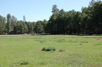
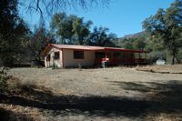
[1] Winter ranch |
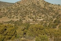
[2] Winter ranch |
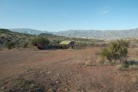
[3] Winter cow camp |
|
|
|
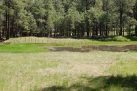
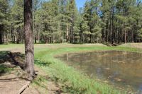
[4] Winter dirt tank |
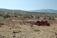
[5] Winter shipping corrals |
[6] Winter storage tanks |
|
|
|
[7] |
[8] |
[9] |
|
|
|
[10] |
[11] |
[12] |
|
- |
- |
[13] |
- |
- |
Location & Maps
Please click on any of the maps
for a larger view
|
|
|
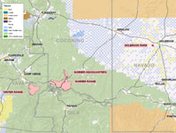
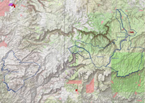
Location Map |
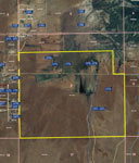
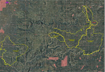
Aerial map -
Holbrook Farm |
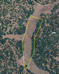
Aerial map -
Summer Headquarters |
|
|
Topography Map |
Aerial map |
The ranch includes a summer range, winter range, summer headquarters, and an irrigated farm as the base property.
Summer and Winter Ranch:
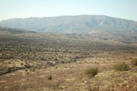
The ranch is located between Camp Verde and Clints Well reaching from the Hackberry Basin up over the Mogollon Rim to Clints Well. The summer and winter range is non-contiguous. The winter range is accessed by the General Crook Trail (Highway 260) east from Interstate 17 at Camp Verde approximately 9 miles to Forest Road 708 (gravel), then southeast ½ mile to the ranch boundary. Continue along FR708 approximately 6 miles to the Needle Rock Cow Camp. The winter range includes Cottonwood Basin, Hackberry Basin and Hackberry Mountain with the Verde River being the entire western boundary. The summer range is located along Highway 260 and Highway 87 as both highways travel several miles through the ranch. Access is by continuing east on 260 approximately 15 miles past FR708, just inside the Coconino County line on top of the Mogollon Rim. The summer ranch is directly along Highway 260 up to the Highway 87 intersection and continuing east approximately 12 miles to Clints Well. The allotment surrounds Clints Well and reaches up the Mormon Lake Road over six miles. The summer range is directly on top of the Mogollon Rim and reaches from Sandrock Canyon to Miller Ridge overlooking the Rim, Pivot Rock, Long Valley and Clints Well and directly neighbors the Long Valley Experimental Forest.
Summer Headquarters:
The summer headquarters is located one mile north of Clints Well and the intersection of Mormon Lake Road and Highway 87. Access is provided by the paved Mormon Lake Road approximately one mile north of Highway 87 to Forest Road 680, then east ½ mile to the property. The summer headquarters is a very private and secluded location with excellent access to a paved highway and is located within the boundaries of the summer range.
Holbrook Farm:
The base property is located between Joseph City and Holbrook directly along MClaws Road within the Joseph City Active Management Area approximately 3 miles south of Interstate 40 and 5 miles west of Holbrook, Arizona. Access is provided by Mclaws Road from the US 180/State 77 intersection. The farm is located on both sides of Mclaws road and includes approximately one mile of frontage.
Land Tenure
10.1 Acres Deeded (Summer Headquarters)
495.5 Acres deeded (Holbrook Farm)
80,314.0 Acres Hackberry-Pivot Rock National Forest Allotment
80,819.6 Acres Total or 126 Sections
Hackberry-Pivot Ranch Allotment on the Coconino and Prescott National Forests.
Coconino County Assessor #402-32-001A (summer headquarters)
Navajo County Assessor #109-12-001 (Holbrook farm)
Carrying Capacity
The winter range consists of the Hackberry Allotment which is allotted for a maximum permitted use of up to 3,800 AUM’s for a five month winter season of use which equates to 760 head from December 1 through April 30. The summer ranges consists of the Pivot Rock Allotment which is allotted for a maximum permitted use of up to 5,250 AUM’s for a seven month summer seas of use which equates to 750 head from May 1 through November 30. These are maximum numbers under ideal conditions and actual running numbers are adjusted on a yearly basis considering weather occurrences and monitoring. The ranch has been stocked according to the most current permit issued in 2011 as follows:
450 cattle winter range (Dec. 1 to April 30) or 2,250 AUM’s
664 cattle summer range (May 1 to Nov. 30) or 4,648 AUM’s
Property Description
Winter Range:
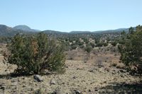
The Needle Rock cow camp is located directly west of Forest Road 708 approximately 6.5 miles from State Highway 260. The camp consists of a 1,200SF, 3 bedrooms, 1 bath wood frame house constructed in the early 1960’s and remodeled. in 2002 with wood siding, wood flooring and metal tin roof. Domestic water is supplied by a nearby spring with small storage tank and gravity flow to the house. Additional buildings include a 2,400SF hay barn of steel beam construction with metal roof and siding with dirt flooring and a wood construction tack shed. There is a small set of working corrals located at the camp primarily used for horses. The winter range varies from rolling hills to mountains terrain with elevation being primarily between 3,500 and 4,500 feet with the highest point on Hackberry Mountain over 5,500. The ranch includes numerous cross-fencing into interior pastures for a rotational grazing pattern. The main set of shipping corrals is located directly off of FR 708 where the cattle are gathered and shipped to or from the summer range. The property is watered by numerous springs scattered throughout the ranch and a shared well supplying over one mile of pipeline with drinkers and 60,000 gallons of storage. Additional livestock water is supplied by numerous dirt tanks. Vegetation consists primarily of blue gramma, black gramma, tobosa, side oats gramma and various annuals.
Summer Range:
The summer range is located directly on top of the Mogollon Rim and contains large stands of Ponderosa Pine forests intermixed with small mountain meadows, canyons and streams. Range improvements include shipping corrals and numerous cross-fences for a rotational grazing plan. Livestock water is supplied by numerous springs and dirt tanks scattered throughout the ranch. Vegetation primarily consists of pine dropseed, Kentucky blue grass, mountain muhly, blue gramma and black gramma. Elevation ranges between 7,000 and 8,000 feet.
Summer Headquarters:
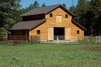
The summer headquarters is located one mile north on Mormon Lake Road from the Highway 87 intersection and ½ mile east of the paved road in a secluded meadow surrounded by large pine trees. The summer headquarters contains 10.1 acres surrounded by National Forest around 95% of the property boundary and includes a 2,224 sq. ft. log sided home with 3 bedrooms, 3 bathrooms. The house has approximately 600 sq. ft. of wrap-around porch space and includes central heat with a fireplace insert and vaulted ceilings. The property is on the grid with land line telephone and general utility electrical service underground to the house. A large livestock and hay barn is also located on the property.
Holbrook Farm:
The farm serves as the base property for the allotments and is utilized primarily in the winter for weaning calves and carrying replacement heifers. The property contains 495 deeded acres with Mclaws Road bisecting the farm from east to west. The property has historically been farmed for alfalfa hay production and more recently for irrigated pasture. The property is located within the boundaries of the Joseph City Irrigation Non-Expansion Area which requires annual reporting on water usage. The farm has grandfathered irrigation rights for 163 acres of irrigated crop land being supplied by five registered wells. Elevation at the farm ranges from 5,050 to 5,100. There are no building improvements on the farm.
Price
Whole ranch with summer headquarters- $2,375,000 – Cash
Ranch and base property (Holbrook Farm) only - $1,575,000 - Cash
Printable
Brochure
 Please click here to download (about 1.25
MB) a printable brochure in Adobe Acrobat format. If you get frustrated
trying to make this work on your computer, don't hesitate to ask us
to mail you a printed and bound brochure instead.
Please click here to download (about 1.25
MB) a printable brochure in Adobe Acrobat format. If you get frustrated
trying to make this work on your computer, don't hesitate to ask us
to mail you a printed and bound brochure instead.


.JPG)