***
OFF THE MARKET ***
49.82± Acres
Town of Buckeye, Maricopa County, Arizona
Pictures
Please click on any of the pictures
for a larger view
|
|
|
|
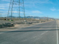
[1]
Looking north from SE corner along Dean Road frontage.
|
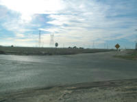
[2]
Looking west along the Lower Buckeye Road alignment on north
boundary
|
Location
& Maps
Please
click on any of the maps for a larger view
|
|
|
|
|
|
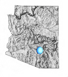
General
location in AZ
|
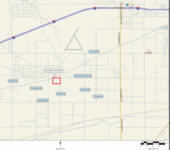
Location
Map
|
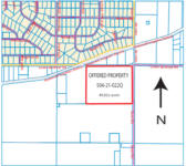
Parcel
Map
|
Satellite
image of property
|
Location
The offered property is located on the southwestern quadrant of Dean
Road and Lower Buckeye Road, in the stripped annexed areas of the
Town of Buckeye. The site is located 2.5 miles south and 1 mile west
of the I-10 – Verrado Way Interchange, (which does not connect
to Airport Road south of I-10 at the present time), and approximately
7 miles northeast of downtown Buckeye.
Access/Frontage
The property has physical access via paved Dean Road frontage
along the east property boundary, and frontage on the south side of
the Lower Buckeye Road alignment. The property does have legal access.
Acreage/Use
49.82± tax roll acres of land. The property is currently
farmed. The cropland is in the Roosevelt Irrigation District, water
is received from a District turnout. The property is bisected by four
large electrical transmission lines. The Seller indicates that there
is approximately 38 acres net of the powerline right of ways.
Water Rights
Approximately 45± irrigation acres, with an irrigation
water duty of 5.34 af per irrigation acre.
Zoning
Maricopa County Rural - 43,000, (R-43), a one acre minimum residential/agricultural
zoning district. Under the existing Buckeye Plan for Future Development,
the subject is designated as Planned Residential.
Flood Hazards
Per FEMA Flood Map #04013C, Panel 2045G, dated 7/19/01,
the offered property is located in a Zone X area, an area outside
of the 100 year flood hazard area.
Utilities
There are no City water and sewer utilities in the area. Utilities
typical to the neighborhood include:
-
Telephone:
Qwest is the primary carrier in the area, and various cellular and
long distance carriers.
-
Electric:
APS.
-
Water:
Domestic wells are permitted.
-
Natural
Gas: Southwest Gas, and various bottled gas suppliers.
-
Sewage:
Individual septic tanks.
-
Television:
Antennae or various satellite services.
Price
$1,995,000
-or- $40,044 per gross acre
-or- $52,500 per acre net of the power lines and roads
Terms
Cash
Printable
Brochure
 Please click here to download (about 200KB)
a printable brochure in Adobe Acrobat format. If you get frustrated
trying to make this work on your computer, don't hesitate to ask us
to mail you a printed and bound brochure instead.
Please click here to download (about 200KB)
a printable brochure in Adobe Acrobat format. If you get frustrated
trying to make this work on your computer, don't hesitate to ask us
to mail you a printed and bound brochure instead.
Note
This
parcel was previously listed with Headquarters West and was temporarily
withdrawn from the market.
Contact
Offered for
sale exclusively by:
Headquarters West, Ltd.
Charles J. Havranek,
email: charlie@headquarterswest.com
810 N 2nd Street
Phoenix, AZ 85004-2016
Phone: (602) 258-1647, Mobile: (602) 377-7083, Fax: (602) 340-0927
- and -
Shawn T. Wood
email: info@headquarterswest.com
810 N 2nd Street
Phoenix, AZ 85004-2016
Phone: (602) 258-1647, Mobile: (602) 290-7516, Fax: (602) 340-0927
Web: www.headquarterswest.com/dean
See Also
 -Sold - 9.43 acres
about a mile to the East; also handled by Shawn Wood
-Sold - 9.43 acres
about a mile to the East; also handled by Shawn Wood
Disclaimer: This information was obtained
from sources deemed to be reliable but is not guaranteed by the Broker.
Prospective buyers should check all the facts to their satisfaction.
The property is subject to prior sale, price change, or withdrawal.
Keywords
- real estate , land , property , acreage , 85343
85338 85323 85329 85340, near Buckeye , Liberty , Rainbow Valley , Palo
Verde , Hassayampa , Arlington , Perryville , Goodyear , Litchfield
Park , Avondale , Cashion , Tolleson , n s e w , Broadway Road , Watson
, Tuthill , Yuma
|