*** OFF THE MARKET ***
Lyman Lake Property
Apache County, Arizona
Pictures
|
|
|
|
|
[1] |
[2] |
[3] |
|
|
|
|
|
[4] |
[5] |
[6] |
|
|
|
|
|
[7] |
[8] |
[9] |
|
|
|
[10] |
[11] |
[12] |
Maps
|
|
|
|
|
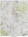
Area
map |
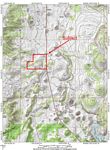
Topo map |
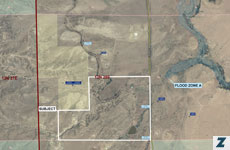
Aerial/Flood map |
Location & Access
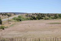
The farm is located in Apache County, Arizona between Springerville and St. Johns and approximately 3 miles north of Lyman Lake. Access is provided by US Highway 180, 18 miles north of Springeville and 6 miles south of St. Johns. The property contains a half mile of paved frontage directly on the west side of US 180.
Land Tenure
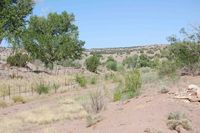
Apache County Assessor Numbers: 202-07-005B & 005E containing 200 acres +/-. Approximately 40 acres is irrigated pasture, currently fallow. The remaining 160 acres is vacant range land located on rolling hillsides overlooking the farm.
Legal Description
Township 12 North Range 28 East
Gila and Salt River Baseline and Meridian
Portion of Section 30
Property Description
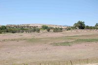
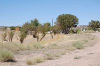
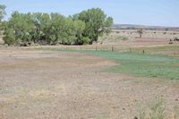
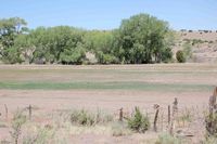
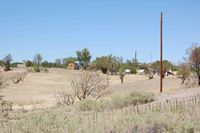
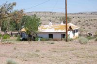
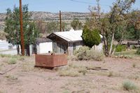
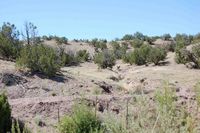
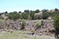
The property is mostly rolling hills with numerous large cottonwood trees growing along the edge of the irrigated fields. The surrounding hillsides are scattered with juniper woodlands. The Lyman Ditch crosses through the property and provides irrigation water from Lyman Lake to the farm. Building improvements consist of two old ranch houses in fair condition and several outbuildings used for storage barns. There is a small orchard with several fruit trees surrounding the building improvements. Elevation on the property ranges from 5,900 to 6,000 feet.
Water
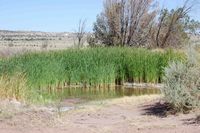
Irrigation water is provided by the Lyman Irrigation and Ditch Company which serves the majority of farms below Lyman Dam and the community of St. Johns. The property has 32 shares of Lyman Irrigation and Ditch Company. Typically, this is enough water to irrigate 15-20 acres of permanent pasture such as alfalfa or grass hay. The property also has two wells registered with the Arizona Department of Water Resources (ADWR). One well is used to supplement the irrigated fields and is equipped with a 7.5 hp submersible pump powered by a diesel generator and produces 125 gallons per minute. The well is drilled 310 feet deep. At the time the well was drilled the well artesian flowed at a rate of 35 gallons per minute. Lyman irrigation water is delivered to the fields via concrete and dirt ditches for flood irrigation. The irrigation well has a 3” pvc pipe delivering water to the upper end of the field and into the dirt ditch. The well is also piped to the pond by the houses and into the orchard for additional irrigation.
Domestic water is provided by the second well which is also 310 feet deep. This well is equipped with a 3 hp electric submersible pump and produces 45 gallons per minute. . There is a second domestic well located at the upper end of the property which is not currently in use and is not registered with ADWR.
Utilities
Electric service is available and in use on the property provided by Navopache Electric Coop. Telephone service is also available via Frontier Communications. Propane is used for heating and cooking with several propane distributors in the area. Sewer service is by septic tank.
Soils
The farm fields are primarily a Navajo sandy clay loam, 3 to 5 % slopes. This soil is on broad alluvial fans. It has a profile similar to the one described as representative of the series, but the surface layer is sandy clay loam about 5 to 8 inches thick. It is not salt and alkali affected. Included in mapping are small areas where the surface layer is gravelly. Runoff is medium, and the hazard of erosion is moderate. This soil is used for range, wildlife habitat, and irrigated crops, such as alfalfa, pasture, and small grains. Capability units IIIe-8, irrigated, and Vie-1, dryland; Clay Bottoms range site, 10 to 14 inches precipitation.
The hillsides surrounding the farm are primarily classified as Moenkopie very rocky loamy sand, 0 to 30 percent slopes. This soil is on plains or hills and escarpments. It has a profile similar to the one described as representative of the series, but depth to bedrock is mainly 5 to 8 inches. Area of Moenkopie loamy sand make up about 60 percent of the acreage, and areas of outcrops of red sandstone make up about 39 percent. Included in mapping, in long, narrow drainage ways, are areas of Tours loam that make up about 1 percent of the acreage. Runoff is rapid, and the hazard of erosion is moderate. This soil is used for range and wildlife habitat. Capability unit VIIs-1, dryland; Shallow Upland range site, 8 to 12 inches precipitation.
Flood Zone
The property is located in zone D: area of undetermined flood hazard. The entire property seems to be located out of any extreme flood hazard except for the natural drainage areas. The property is included in the FEMA flood map #04001C4150E.
Zoning
Apache County General Rural, this is a general agricultural zoning.
Property Taxes
2008 - $615.39
Price
$420,000 – Cash
Contact
Offered
for sale exclusively by:
Traegen H. Knight
Headquarters West, Ltd.
PO BOX 1980
St. Johns, AZ 85936
Phone: (928) 524-3740, Fax: (928) 563-7004, Cell: (602) 228-3494
Email: info@headquarterswest.com
Web: www.headquarterswest.com/lyman