This is an out-of-date, archived version of a listing.
Please visit the latest version on our new website at:
Old Greer Ranch
St. Johns, Apache County, Arizona
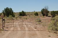
Pictures
Please
click on any of the pictures for a larger view
|
|
|
[1]
|
[2]
|
[3] |
|
|
|
[4] |
[5] |
[6] |
|
|
|
[7]
|
[8] |
[9] |
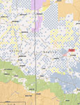
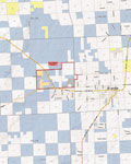
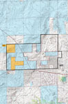
Location
& Maps
Please click on any of the maps
for a larger view
|
|
|
|
|
|
General
location in Arizona |
Neighborhood
map |
Topo
Map |
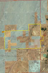
Aerial
map
|
Land Tenure
1,330 acres |
Deeded (44%) |
360 acres |
Private Lease (12%) |
1,300 acres |
State Lease (44%) |
2,990 acres |
Total or 4 Sections |
Legal Description
Deeded:
Township 13 North, Range 27 East Gila & Salt River Base & Meridian
Sections: 13, 14, 23 & 24: portions thereof
Township 13 North, Range 28 East Gila & Salt River Base & Meridian
Section 19: portion thereof
Assessor's Tax Parcel No.: 203-01-003, 203-04-003 & 203-22-003
Carrying Capacity
25 head |
Deeded |
4 head |
Private Lease |
16 head |
State |
42 head |
Total of Adult Cattle Yearlong |
Carrying Capacity based on Arizona lease of 8 head per section.
Location and Access
Located directly west of St. Johns approximately 6 miles west on Highway 180. Access is provided by Highway 180 traveling through the ranch north from State highway 61.
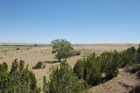
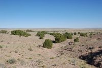
Property Description
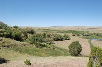
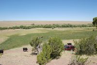
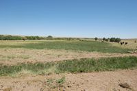
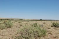
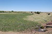
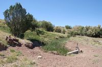
Topography is level to gently rolling hills with open grasslands and some browse species. The deeded land reaches eastward back toward St. Johns up on the hill just west of town. There are no building improvements on the ranch with contributory value. There is one old, homestead adobe house which is partial caved in beginning to fall down. The eastern property has several small springs on the property which feeds two small ponds for livestock water and sub-irrigates over 40 acres of pasture. Historically, the springs were used to irrigate a small orchard, garden and some pasture in front of the homestead.
Utilities
None currently in use on the property. Utilities are available to the immediate area. Service providers are Navopache Electric Co-op and Frontier Communications for telephone service.
Water
There are several earthen stock tanks scattered across the ranch. There are several springs which come out of the side of the hill above and along the main drainage through the ranch. These springs provide live running water for livestock use and some small areas of sub-irrigated meadow on a year-round basis.
Soils
-
Clovis-Palma-Hubert association:
Well-drained, deep, nearly level to undulating loamy sands and gravelly loams formed in eolian sands and alluvium.
-
Tours-Jocity association:
Well-drained, deep, nearly level to gently sloping clay loams and sandy clay loams formed in alluvium.
Flood Zone
Flood Zone C – areas of minimal flooding except natural drainage areas which are flood Zone A.
Zoning
Apache Co.: General Rural
Economic Characteristics
-
8 head per section (State Lease)
-
2016 State Grazing Lease Fee: $3.45/AUM
-
2016 Property Taxes: $82.22
Price
$735,000 - cash
Printable
Brochure
 Please click here to download (about 2
MB) a printable brochure in Adobe Acrobat format. If you get frustrated
trying to make this work on your computer, don't hesitate to ask us
to mail you a printed and bound brochure instead.
Please click here to download (about 2
MB) a printable brochure in Adobe Acrobat format. If you get frustrated
trying to make this work on your computer, don't hesitate to ask us
to mail you a printed and bound brochure instead.
Contact
Offered
for sale exclusively by:
Traegen H. Knight
Headquarters West, Ltd.
PO BOX 1980
St. Johns, AZ 85936
Phone: (928) 524-3740, Fax: (928) 563-7004, Cell: (602) 228-3494
Email: info@headquarterswest.com
Web: www.headquarterswest.com/oldgreer
Disclaimer:
This information was obtained from sources deemed to be reliable but
is not guaranteed by the Broker. Prospective buyers should check all
the facts to their satisfaction. The property is subject to prior
sale, price change, or withdrawal.
Keywords - real
estate , land , property 85290 85925 85932 85927 85938 85940 85924
85936 86509 86502 near n s e w north south east west springerville
witch well concho floy eagar nutrioso alpine beaverhead