*** OFF THE MARKET ***
Note: We have also listed a 49.82 acre parcel to the North on Lower Buckeye Road

142.232± Acres
Rainbow Valley, Maricopa County, Arizona

Location, Access, Frontage & Maps

Please click on any of the maps for a larger view
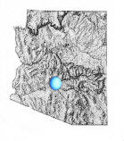
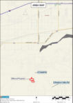
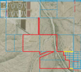
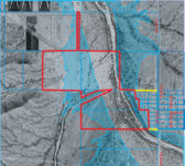
General location in Arizona

Location Map

Satellite Image

Flood Map

The parcel is located to the west of Tuthill Road, and ¼ mile north of the Pecos Road alignment. The property has two 40’ wide access easements to Tuthill Road. The property is located southeast of the Town of Buckeye, and southwest of the City of Goodyear, approximately 11 miles south of I-10, and 330’ to 770’ west of Tuthill Road.

Site
This site is an irregular shaped parcel of desert land that is best described by reviewing the attached aerial map.

Buildings
None

Flood Hazards
Portions of the property are located in a Zone AE Channel and AE Fringe created by Watermans Wash. (Please see the flood map above.)

Zoning
County Rural 43,000, or R-43

Price
$2,133,480

Terms
Cash

Printable Brochure
Please click here to download (about 500KB) a printable brochure in Adobe Acrobat format. If you get frustrated trying to make this work on your computer, don't hesitate to ask us to mail you a printed and bound brochure instead.

Contact

Offered for sale exclusively by:
Headquarters West, Ltd.
Charles J. Havranek, Salesman, charlie@headquarterswest.com

810 N 2nd Street
Phoenix, AZ 85004-2016
Phone: (602) 258-1647, Mobile: (602) 377-7083, Fax: (602) 340-0927
Web: www.headquarterswest.com/rainbow

Disclaimer: This information was obtained from sources deemed to be reliable but is not guaranteed by the Broker. Prospective buyers should check all the facts to their satisfaction. The property is subject to prior sale, price change, or withdrawal.