Pictures
Location
& Maps
Please
click on any of the maps for a larger view
|
|
|
|
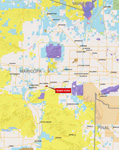
General
location within Arizona |
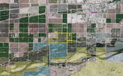
Neighborhood around Buckeye |
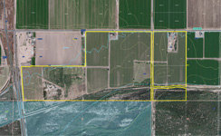
Aerial map with flood and soils |
Location & Access
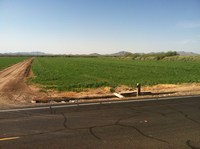
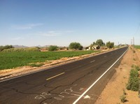
The farm is located on the southwest side of Buckeye Arizona within the Buckeye Water and Conservation Drainage District service area. The property is entirely south of Hazen Road between State Highway 85 (Oglesby Road) and Rooks Road (part of the property lies east of Rooks Road). There is approximately ¼ mile of frontage along Highway 85 and ¾ mile frontage along Hazen Road. Access is provided by ¾ mile of paved frontage along Hazen Road.
Land Tenure
297.11+/- gross deeded acres per county assessor records
Legal Description
Township 1 South, Range 4 West
Gila and Salt River Baseline and Meridian
Being a portion of section 12
Township 1 South, Range 3 West
Gila and Salt River Baseline and Meridian
Being a portion of section 7
Maricopa County Assessor parcel numbers
-
400-37-012
-
400-37-013A
-
400-37-013B
-
401-02-002D
-
401-02-002F
-
401-02-009A
Property Address
26101 West Hazen Road, Buckeye, Arizona 85326
Property Description
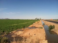
The property is primarily irrigated farmland currently in bermuda and alfalfa fields utilized for baled hay. A portion of the property is native desert consisting of thick mesquite and tamarisk brush. The property is served by the Buckeye Water and Conservation Drainage District. The Arlington Canal crosses through a portion of the property. There are two existing sites containing buildings each containing mobile homes and various farm out buildings.
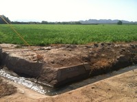
Aggregate Potential
The property has been explored for aggregate and drilling data is available upon request.
Water
Irrigation water is supplied by the Buckeye Water and Conservation Drainage District (BWCDD) and has Grandfathered water rights on file with the Arizona Department of Water Resources (ADWR) as follows:
Right #: 58-115504
2011 Allotment: 1,363.67 acre feet
Water Duty Acres: 177.1
Irrigation Acres: 182.5
Water Duty: 7.7
File Status: Active-Active
Use: Irrigation Use
The current water assessment for BWCDD is $18.00 per acre foot.
There is also one domestic well on record with ADWR and is registered as #55-64996.
Soils
The soil types are considered suitable for farming as the property is currently and has historically been utilized for standard field crops such as cotton, various grains, alfalfa and other hay crops. The Natural Resource Conservation Service (NRCS) has surveyed the area for soils and has found the following soil types:
- Avonda clay loam – approximately 10%
- Avondale clay loam – approximately 28%
- Avondale clay loam, saline-alkali – approximately 5%
- Carrizo and Brios soils – approximately 4%
- Gilman loam, 0 to 1% slopes – approximately 20%
- Gilman loam, saline-alkali – approximately 19%
- Glenbar clay loam – approximately 14%
Flood Zone
The property is included in the National Flood Insurance Program and is mapped on the Flood Insurance Rate Map (FIRM) number 04013C2505H revised September 30, 2005.
The property includes the following zones:
-
Flood Zone X: areas of 0.2% annual chance flood; areas of 1% chance flood with average depths of less than 1 foot or with drainage areas less than 1 square mile; and areas protected by levees from 1% annual chance flood. approximately 10%
-
Flood Zone AE: Base Flood Elevations determined. Special flood hazard areas subject to inundation by the 1% annual chance flood. The 1% annual chance flood (100-year flood), also known as the base flood, is the flood that has a 1% chance of being equaled or exceeded in any given year. approximately 90%
Zoning
The property is located in an unincorporated area of Maricopa County and is currently designated as R-43 which is a rural agricultural designation with a minimum lot size of one acre. The property is also included in the future land use map for the Town of Buckeye and is designated as Regional Commercial.
Additional information
See the following links for additional community and/or zoning information:
Property Taxes
2016 - $10,678.12
Price
$7,500,000 – Cash
Printable
Brochure
 Please click here to download (about 5mb) a printable brochure in Adobe Acrobat format. If you get frustrated
trying to make this work on your computer, don't hesitate to ask us
to mail you a printed and bound brochure instead.
Please click here to download (about 5mb) a printable brochure in Adobe Acrobat format. If you get frustrated
trying to make this work on your computer, don't hesitate to ask us
to mail you a printed and bound brochure instead.
Contact
Offered
for sale exclusively by:
Headquarters West, Ltd.
Traegen H. Knight
PO BOX
1980
St. Johns, AZ 85936
Phone: (928) 524-3740, Fax: (928) 563-7004, Cell: (602) 228-3494
info@headquarterswest.com
www.headquarterswest.com