*** SOLD ***
Udall Ranch
Apache County, Arizona
Pictures
Please
click on any of the pictures for a larger view
|
|
|
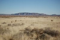
[1]
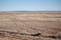
Typical range land |
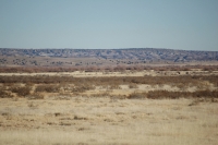
[2] Little Colorado River |
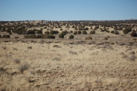
[3] Typical range land |
|
|
|
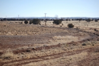
[4]
Typical range land |
[5] Fallow farm land |
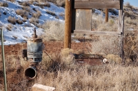
[6]
Irrigation well |
|
- |
- |
[7]
Fallow farm land |
- |
- |
Location, Maps, and Access
|
|
|
|
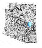
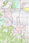
General
location in AZ |
Location
map |
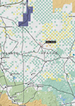
Topo
map |
Aerial map |
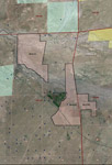
The property is located near the intersection of US Highway 180 and 180A in the Hunt Valley along the Little Colorado River in Apache County approximately 18 miles northwest of St. Johns and 10 miles north of Concho, Arizona. Access is provided by paved US Highway 180 with nearly one mile of frontage. County Road #5392 and #5152 provide additional access through the ranch.
Land Tenure
1,700 deeded acres
Legal Description
Township 14 North Range 25 East
Gila and Salt River Baseline and Meridian
Portion of Sections 2, 12 & 13
Township 14 North Range 26 East
Gila and Salt River Baseline and Meridian
Portion of Section 18
Apache County Assessor parcel numbers
204-01-012 & 204-10-002
Property Description
The ranch is located in two non-contagious parcels approximately ¾ mile apart. Both parcels have access to the county roads and include the Little Colorado River running through portions of the property. One parcel also includes over one mile of the Zuni River running through the property. The property consists of primarily vacant land with rolling hills and nearly level meadowland adjacent to the Little Colorado River. There is a house on the property near the eastern most boundary and directly off county road #5152. The house is not in livable condition and was originally built over fifty years ago. The boundary includes nearly one mile of highway frontage along US Highway 180 and over a half mile of river frontage. Elevation on the ranch varies from 5,400 to 5,470 feet.
Vegetation
Vegetation includes plains and desert grassland with scattered juniper trees on the rolling hill portion. The low land near the river is nearly level open grassland with chamisa and sage. The low land was cleared for farming many years ago, but has mostly been grown in with native vegetation.
Water
There is one well on the property originally drilled over fifty years ago. Area wells vary from 100 feet to 500 feet deep with maximum pumping capacities of 1,000 to 1,800 gpm. The surrounding area has been farming for many years with irrigation water supplied by wells. The ranch well has historically been used for livestock and domestic purposes only although some irrigation would be possible. The ranch has not had any active farming on the property for over fifty years. The Little Colorado River has a seasonal flow and typically only runs during the summer monsoon months.
Utilities
Public telephone and electricity is available to the property boundary but is not currently in use or hooked up to the property. Frontier Communications is the telephone provider and Navopache Electric Cooperative is the electric provider.
Flood Zone
Flood Zone C: areas of minimal flood hazard and Flood Zone A: areas of 100-year flood hazard.
Please see the flood map overlay on the maps above.
Price
$1,000,000 – Cash
Printable
Brochure
 Please click here to download (about 2 MB)
a printable brochure in Adobe Acrobat format. If you get frustrated
trying to make this work on your computer, don't hesitate to ask us
to mail you a printed and bound brochure instead.
Please click here to download (about 2 MB)
a printable brochure in Adobe Acrobat format. If you get frustrated
trying to make this work on your computer, don't hesitate to ask us
to mail you a printed and bound brochure instead.
Contact
Offered
for sale exclusively by:
Traegen H. Knight
Headquarters West, Ltd.
PO BOX 1980
St. Johns, AZ 85936
Phone: (928) 524-3740, Fax: (928) 563-7004, Cell: (602) 228-3494
Email: info@headquarterswest.com
Web: www.headquarterswest.com/udall
See Also
Traegen Knight has also handled the adjacent Hunt property
Disclaimer:
This information was obtained from sources deemed to be reliable but
is not guaranteed by the Broker. Prospective buyers should check all
the facts to their satisfaction. The property is subject to prior
sale, price change, or withdrawal.
Keywords - real
estate , land , property 85290 85925 85932 85927 85938 85940 85924
85936 86509 86502 near n s e w north south east west springerville
witch well concho floy eagar nutrioso alpine beaverhead