*** SOLD ***
Coyote Creek Development Property
Apache County, Arizona
Pictures
Please
click on any of the pictures for a larger view
|
|
|
|
|
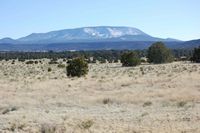
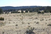
[1] View from northern boundary looking south over the property. |
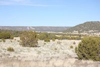
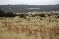
[2] Typical rolling hills on the property |
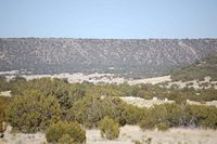
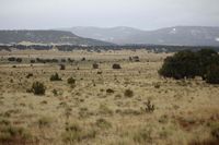
[3] View looking east over the property to Escudilla Bonita Acres development in the distance |
|
|
|
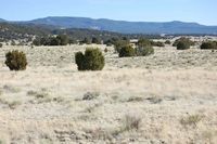
[4] Typical rolling hills on the property |
[5] |
[6] |
|
- |
- |
[7] |
- |
- |
Location
& Maps
Please click on any of the maps
for a larger view
|
|
|
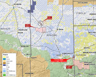
| Location
map |
Access
Map |
Topo map |
Property Identification
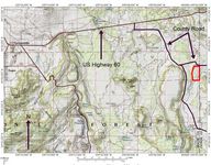
The property contains 316 acres roughly rectangular in shape being one mile from north to south and a half mile from east to west. The southern boundary is the Apache-Sitgreaves National Forest while the northern and western boundaries are Arizona State Trust lands. The eastern boundary is the New Mexico State line and immediately adjacent to the Escudilla Bonita development in New Mexico. The property is located approximately 14 miles east of Springerville, Arizona along Coyote Creek. Coyote Creek travels through the property for nearly a half mile diagonally from the southwest to the northeast. Approximately half the property consists of open meadowland adjacent to the creek with the remaining half being thickly tree covered benches overlooking the creek. Tree cover consists of pinion/juniper woodlands. Elevation ranges from 7,280 along the creek to 7,280 on the rolling hills in the northwest corner of the property.
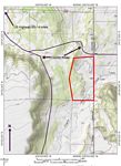
Access
Provided by US Highway 60 east 8 miles to gravel county road #4225, then southeast 5 miles to county road #4000, then east 1 mile to the New Mexico State line. The property lies less than 1/8 mile south of the county road.
Legal Description
Township 8 South, Range 31 East
Gila and Salt River Base Line & Meridian
Sections 11: All, the section contains slightly less than a half section being cut short by the New Mexico State Line.
Taxes Parcel Numbers
Tax Year 2008
APN |
ACRES |
FCV |
TAXES |
104-39-003 |
316.00 |
3,968.00 |
45.56 |
Utilities
Public telephone and electricity is available to the Escudilla Bonita development immediately adjacent to the subject property in New Mexico. There are no public utilities in use on the subject property.
Water
There is no developed domestic water source on the property. Domestic wells can be drilled in the area and vary in depth from 50 to 200 feet deep. Surface water is supplied by Coyote Creek seasonally for livestock use only. The creek is not a year-round running water source and typically only runs during the summer monsoon months from July through September and during the spring snow “runoff” season from March through April.
Area Climate
The closest U.S. Weather Bureau Reporting Station having complete records for the area are Quemado and Springerville. These records were taken from the Western Regional Climate Center records recorded from 1915 & 1938 through 2006.
Average Temperature – at Quemado, NM:
Month Maximum Minimum
January 46.7° 13.1°
July 85.1° 50.7°
Average Annual Precipitation: 10.74 inches.
Average Temperature – at Springerville, AZ:
Month Maximum Minimum
January 47.6° 15.2°
July 82.3° 51.1°
Average Annual Precipitation: 11.9 inches.
Area Info
Springerville and Eagar, Arizona are the closest communities to the property. The primary governmental agencies are Apache National Forest with headquarters and the Springerville Ranger District offices in Springerville, and Apache County, with the County Seat in St. Johns. The other major employers are the Salt River Project Coronado Generating Station at St. Johns and Tucson Electric Power at Springerville. Springerville and Eagar are immediate town neighbors and together provide basic service and supply facilities, the 25-bed White Mountain Regional Medical Center, elementary and high school education, several banks, a large multi-purpose domed facility for high school sports, concerts, etc., parks, and churches.
Area Attractions
The following information was obtained from the www.springerville.com
-
Greer and Alpine: A short drive to the south, you'll find the mountainside communities of Greer and Alpine. At elevations in excess of 8,000 feet, many residents of the urban communities of Phoenix and Tucson find the destination of the White Mountains as an escape from the summer heat, to marvel in the explosion of colors each fall, or to enjoy the winter recreational opportunities of skiing and snowmobiling in the winter. Primarily tourist destinations, these two community's popularity as a corporate retreat is growing, and with the shopping, dining, and site seeing opportunities, you're sure to find activities for the entire family.
-
Lyman Lake State Park: Located just minutes from out of town, between St. Johns and Springerville, this 1,180-acre park encompasses the shoreline of the man-made reservoir. As one of the largest lakes in northeastern Arizona, there are no size restrictions on boats, thus allowing for speed boats and water skiing. The park features improved campgrounds and hookups, and its group ramadas are popular locations for local residents. Paved boat ramps, restrooms, showers, and a small herd of buffalo that reside in the park make the park a unique destination for residents and visitors. Special interpretive programs, tournaments, and fireworks are available throughout the summer months.
-
Sunrise Ski Resort: 65 runs over three mountains, separate snowboarding area, cross country ski trails, and a special children's area make this resort one of the most popular in the southwest. Owned and operated by the White Mountain Apache Tribe, the high speed quad chairlifts, with a capacity in excess of 16,000 skiers per hour, are also open during the spring months for scenic viewing.
-
Big Lake Recreation Area/Apache-Sitgreaves National Forests: An integral part of the communities is the Apache-Sitgreaves National Forests, home to one of the largest stands of Ponderosa Pine in the world. The 2-million acre forest is home to more than 410 species of wildlife. Each year, the 35 lakes, 680 miles of streams, 36 campgrounds, and over 950 miles of trails are visited over 5 million times. The Big Lake Recreation Area is home to one of the largest newly developed recreation facilities, featuring improved campgrounds, hookups, and shower facilities. During the winter months, the Apache-Sitgreaves National Forest is also home to one of the largest winter recreation areas in the southwest, where cross-country skiing trails, snowmobile rentals, and sledding areas are open to the public.
-
Casa Malpais Ruins: The Casa Malpais Pueblo is of the Mogollon Culture. It is located within the town limits of Springerville, Arizona at an elevation of 7000 feet. The site is dated from 1240 AD, to 1350 AD. The site includes a 60 room pueblo, ceremonial structures, a great Kiva and a Solar Calendar. The pueblo sits above and overlooks the Little Colorado River and has a magnificent view of the White Mountains. The area will delight the geologists, naturalists, archaeologists or historians in all who visit. The site is by guided tour only, 9am, 11am, and 2pm, weather permitting year roun
Price
$500,000 – Cash
Printable
Brochure
 Please click here to download (about 1.25
MB) a printable brochure in Adobe Acrobat format. If you get frustrated
trying to make this work on your computer, don't hesitate to ask us
to mail you a printed and bound brochure instead.
Please click here to download (about 1.25
MB) a printable brochure in Adobe Acrobat format. If you get frustrated
trying to make this work on your computer, don't hesitate to ask us
to mail you a printed and bound brochure instead.
Contact
Offered
for sale exclusively by:
Traegen H. Knight
Headquarters West, Ltd.
PO BOX 1980
St. Johns, AZ 85936
Phone: (928) 524-3740, Fax: (928) 563-7004, Cell: (602) 228-3494
Email: info@headquarterswest.com
Web: www.headquarterswest.com/hbarv
See
Also
Also handled
by Traegen Knight in the area:
- H Bar V - The Coyote Springs Development Parcel is also available as part of the H Bar V Ranch
- Udall Ranch - 1,700 acres in Apache County
- Concho Ranch - 31,471 acres in Apache County
- Sold -
Goodwater Ranch
- 56,158 acres in Navajo County
- Sold - Greens
Peak Ranch
- 17,938 acres Apache County
Handled
by Con Englehorn in the area:
- Sold
- Chevelon Canyon, 66,370 acres/728
AU in Navajo County
Disclaimer:
This information was obtained from sources deemed to be reliable but
is not guaranteed by the Broker. Prospective buyers should check all
the facts to their satisfaction. The property is subject to prior
sale, price change, or withdrawal.
Keywords - real
estate , land , property 85290 85925 85932 85927 85938 85940 85924
85936 86509 86502 near n s e w north south east west springerville
witch well concho floy eagar nutrioso alpine beaverhead |