*** SOLD ***

Eagar Farm
Apache County, Arizona

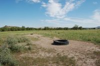
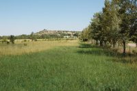
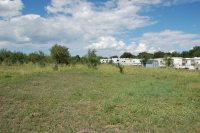
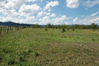
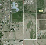
Pictures

Please click on any of the pictures for a larger view

[1] Farm entrance looking N from the SW corner
[2] View looking W along 4th St. and the Southern boundary
[3] View looking N across the irrigated portion of the property
[4] Head-gate along 4th Street.
[5] Tire drinker supplied by city water meter near the central portion of the farm
[6] View from the SE corner looking N along the Eastern boundary
[7] View of the N property line with RV park in the distance
[8]
[9]

Location & Maps

Please click on any of the maps for a larger view

Location map
Topo of the farm
Parcel map
Aerial map of the parcel

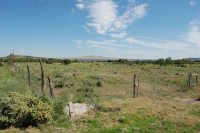
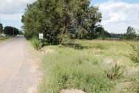
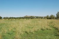
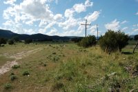
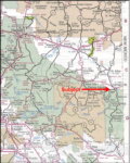
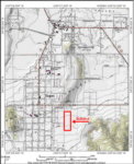
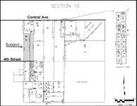
The farm is located in the central part of Eagar directly off of 4th Street and immediately adjacent to the Intermediate School. Eagar is located on State Highway 260 approximately 200 miles northeast of Phoenix and 190 miles southwest of Albuquerque, New Mexico. The Springerville/Eagar area is known as the "gateway" to the White Mountains being located in the foothills of the mountains which include the Apache/Sitgreaves National Forest and Mt. Baldy, the second highest peak in Arizona. Access to the farm is by 4th street, east approximately a half mile from Eagar's Main Street. The south boundary of the property has approximately 660 feet of paved frontage along 4th Street.

Neighboring Land Use
The property is located within the Eagar town limits neighbored on the north by the Bear Paw RV Park, the west by the Round Valley Intermediate School and single family housing and the south and east by other irrigated farms with single family dwellings.

Land Tenure
27 deeded acres within the Eagar town limits.

Legal Description:
Township 8 North Range 29 East
Gila and Salt River Baseline and Meridian
Portion of the northwest quarter of section 10.

Apache County Assessor Number 104-23-005C

Property
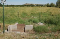
 Description
There are no building improvements on the property. The farm has not actively been farmed in over 10 years, although irrigation water has been flooded over the native pasture grasses and grazed with livestock. There are numerous elm and juniper trees scattered across the field. The irrigation ditch runs along the southern boundary (4th street) and has two turn-outs to the field. The farm has no concrete ditches and has been leveled by hand many years ago. The entire perimeter is fenced with 4 strands of barbed wire on both metal and wooden posts.

Elevation on the property ranges from 7,110 to 7,140 with the irrigation water running from south to north across the length of the farm.

Water
Irrigation water is provided by the Pioneer Irrigation Company which serves the majority of Springerville and Eagar. The property has 550 shares of Pioneer Irrigation Company which provides approximately 11 hours of water per turn. The number of turns varies depending on the available water storage in the reservoirs. Turns begin on April 15th of each year and come every 7 to 10 days. Depending on the reservoir storage the farm may receive anywhere from 2 to 10 turns of water in a growing season.

Domestic water is available and currently in use on the property. There is a city water hook-up and meter in use on the western boundary of the farm near the central north/south line. Currently the water is piped approximately 20 feet to a tire drinker and utilized for livestock only.

Soils Eagar loam, 1 to 3 percent slopes: This soil is on the middle and lower parts of broad alluvial terraces. It has a profile representative of the series, but the surface layer is about 5 percent gravel and is about 15 inches think. Depth to the zone of lime accumulation ranges from 14 to 24 inches in a few places. Runoff is medium, and the hazard of erosion is moderate. This soil is used for irrigated crops and home sites. Capability units IVe-6, irrigated, and VIs-1, dryland.

Fruitland loam, cold variant, 1 to 5 percent slopes: This soil is on alluvial fans along the outside edges of mountain valleys. Runoff is slow. The hazard of erosion is slight, and the hazard of soil blowing is moderate. This soil is used for range and irrigated farming. The principal crops are corn or sorghum for silage, alfalfa, and small grains. Capability units IIIe-1, irrigated, and Vie-1, dryland.

Flood Zone
The property is located in zone X: areas of unknown flood hazard.

Zoning
City of Eagar - AR-43. This is a general agricultural zoning with a one-acre minimum lot size for property splits, with a 100 foot minimum of city street frontage per lot.

Property Taxes
2006 - $678.34 - Paid

Price
$225,000 - Cash

Printable Brochure
Please click here to download (about 1.7MB) a printable brochure in Adobe Acrobat format. If you get frustrated trying to make this work on your computer, don't hesitate to ask us to mail you a printed and bound brochure instead.

Contact
Offered for sale exclusively by:
Traegen H. Knight
Headquarters West, Ltd.
PO BOX 1980
St. Johns, AZ 85936
Phone: (928) 524-3740, Fax: (928) 563-7004, Cell: (602) 228-3494
Email: info@headquarterswest.com

Web: www.headquarterswest.com/eagarfarm

See Also
Also handled by Traegen Knight that may be of interest
- Sold -
Hunt Property - 56,158 acres in Navajo County

Disclaimer: This information was obtained from sources deemed to be reliable but is not guaranteed by the Broker. Prospective buyers should check all the facts to their satisfaction. The property is subject to prior sale, price change, or withdrawal.

Keywords - real estate , land , property near n s e w north south east west