Wildhorse Basin Ranch
Yavapai County, Arizona
Pictures
Please
click on any of the pictures for a larger view
|
|
|
[1] |
[2] |
[3] |
|
|
|
[4] |
[5] |
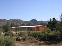
[6] Main residence |
|
|
|
[7] Main residence |
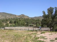
[8] Horse barn |
[9] Corral |
Location, Access
& Maps
Please click on any of the maps
for a larger view
|
|
|
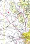
General
location
in Arizona |
Topo/tenure map |
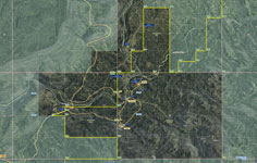
Aerial map
|
Location
The Wildhorse Basin Ranch is located in Yavapai County in central Arizona. It is on Camp Wood Road 7 miles northeast of Bagdad. Phoenix is 130 miles southwest and Prescott is 67 miles to the east.
Description
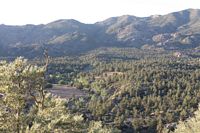
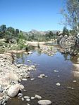
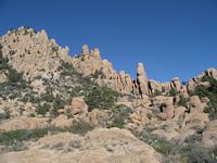
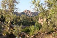
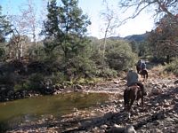
The Ranch lies in a scenic basin ringed on the north, south, and east by mountains. The deeded land is strategically located on the west side of the basin controlling access into the interior of the property. Boulder Creek runs along the western side on the deeded land. This is a perennial creek with classic riparian vegetation. Wildlife in the basin and surrounding mountains includes deer, javalina, coyote, fox, bobcat, rabbits, quail, and numerous species of birds.
Estimated carrying capacity 110 adult cattle yearlong.
Land Tenure
Deeded 864 acres
Arizona State Grazing Lease - 6,701 acres
Total - 7,565 acres
Improvements
- Main Residence - 2,880 sq ft; three level earth system construction;3 bedroom, living room, dining room, family room, 21/2 baths. lower level garage/shop storage.
- Other buildings include horse barn, storage shed, well house, and generator shed.
Water
Irrigation water rights from Boulder Creek for 100 acre feet per annum. Domestic water provided by a well. Livestock water provided by wells, springs, and Boulder Creek.
Irrigation sprinkler system not currently operational.
Vegetation, Elevation & Climate
The ranch is in the pinion pine-juniper vegetative type. Primary vegetation consists of pinion pine and juniper trees, mountain laurel, oak brush, service berry, buckwheat, quajilla, and cliff rose. Grasses include bluestem, tobosa, threeawns, needlegrass, sidoats grama. Vegetation along Boulder Creek includes classic riparian plant community including sycamore, desert willow, cottonwood, and ash trees.
The elevation varies from 4,241 feet along Boulder Creek and at the building sites to 5,600 feet in the mountains on the northern edge.
Weather records at Bagdad, elevation 3,712, indicate average annual precipitation of 13.44 inches. Mean maximum July temperature is 96.5 degrees and mean minimum January temperature is 33.1 degrees.
Utilities
Solar systems with generator backup at each building site. Cell phone/booster at the residence. Fiber optic line is under construction.
Taxes and Fees
- Real estate taxes, 2011-12 - $1,378.30
- Arizona State Grazing fee, 2012-13 - $3,016.00
Price
$3,900,000
Printable
Brochure
 Please click here to download (about 11
MB) a printable brochure in Adobe Acrobat format. If you get frustrated
trying to make this work on your computer, don't hesitate to ask us
to mail you a printed and bound brochure instead. Please click here to download (about 11
MB) a printable brochure in Adobe Acrobat format. If you get frustrated
trying to make this work on your computer, don't hesitate to ask us
to mail you a printed and bound brochure instead.
Contact
Offered
for sale exclusively by:
Con Englehorn
Headquarters West, Ltd.
8700 E Pinnacle Peak, #223
Scottsdale, AZ 85255
Phone: (602) 258-1647, Fax: (602) 340-0927
Email: info@headquarterswest.com
Web: www.headquarterswest.com/wildhorsebasin
Disclaimer:
This information was obtained from sources deemed to be reliable but
is not guaranteed by the Broker. Prospective buyers should check all
the facts to their satisfaction. The property is subject to prior
sale, price change, or withdrawal.
|