*** SOLD ***
Hassaymapa River Ranch
Yavapai County, Arizona
Pictures
|
|
|
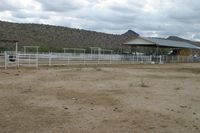
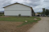
[1] Barn & Corrals |
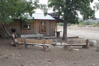
[2] Cabin & Firepit |
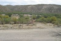
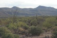
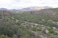
[3] East side of river mesquite canyon ranch |
|
|
|
[4] Generator shop |
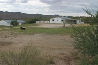
[5] Girls home and vacant barn |
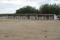
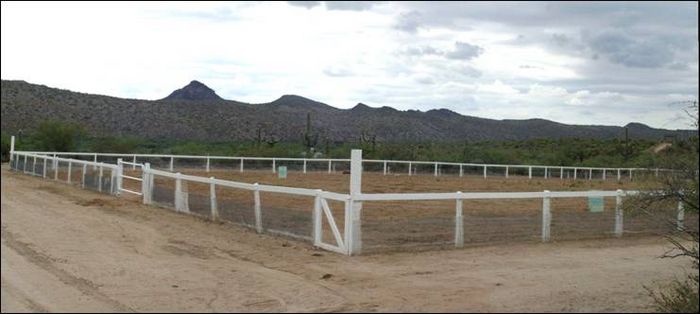
[6] Horse pens |
|
|
|
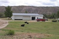
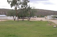
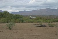
[7] HQ looking south from lawn near shop |
[8]
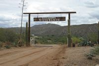
Entrance |
[9] Main home and water tower from across river |
|
|
|
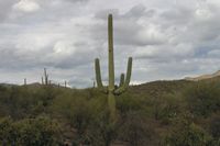
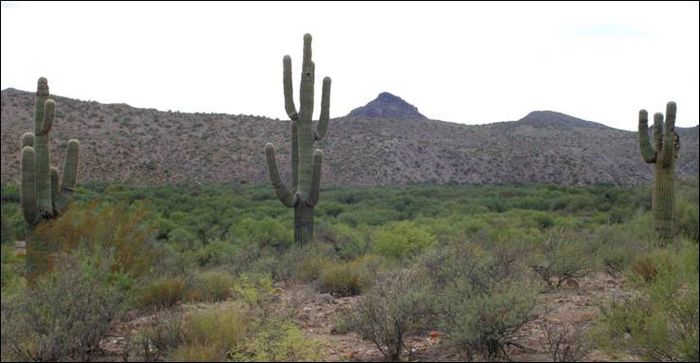
[10] Saguaros on BLM |
[11] Shop garage |
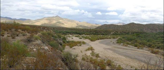
[12] View of HQ from Fools Canyon |
|
|
|
[13] Wagoner Mountains from Fools Canyon |
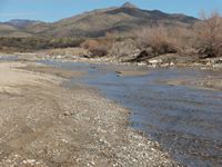
[14] Seasonal Hassayampa River flows January 2011 looking N |
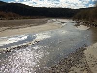
[15] Seasonal Hassayampa River flows January 2011 looking S |
Location
|
|
|
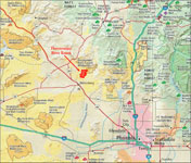
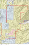
Location
map |
Topo
Map |
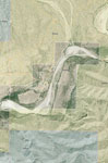
Aerial Map |
The Hassayampa River Ranch is located approximately 13.5 miles north of historic Wickenburg, Arizona. Access from downtown Wickenburg is about 4.5 miles on US 93 and about 9 miles on dirt Scenic Loop Road. Wickenburg is a short drive from the Phoenix Metro area, with the west valley cities of Surprise and Peoria averaging about a 30 to 40 mile drive. Both downtown Phoenix to the south and Prescott to the north are about 60 miles from the ranch.
Acreage & Carrying Capacity
- |
Acres |
% |
Carrying Capacity |
| Deeded |
279.99 |
4.26 |
- |
| State lease |
2,012.86 |
30.26 |
16 |
| BLM |
4,280.00 |
65.12 |
61 |
| Total |
6,572.85 |
100.00 |
77 |
The carrying capacity for the State and BLM grazing leases are set by each agency.
Description
The ranch is on the Hassayampa River in the northern stretches of the Sonoran desert. Hassayampa is an Apache word that roughly translates to “river which runs upside down.” On the ranch, the Hassayampa runs water on the surface seasonally, typically during the cooler months and during the summer Monsoons. There is approximately 1¼ miles of the river running through the ranch deeded land.
The headquarters is between 2,300’ to 2,400’ in elevation. Views are exceptional of the surrounding Weaver, Bradshaw and Wickenburg Mountains. The majority of the deeded land is level to rolling and there is ample space for development out of any flood hazards of the river. The deeded land is surrounded by BLM land with the exception of the southwestern boundary. The bordering parcel is called the Boyd Ranch and is owned by the Desert Caballeros Western Museum to preserve this unique area. A portion of the deeded land was once irrigated. Well registration information with the Arizona Department of Water Resources indicates that the wells were used to irrigate 50 to 80 acres at one time.
The highest point on the ranch is 3,650’ near Sam Powell Peak. The ranch is level to rolling with several washes and the Hassayampa River running through it. The ranch is a single pasture with the boundary being fenced. There are several smaller fenced holding pastures at the headquarters as well as pipe corrals. There is a small set of corrals for a trap at the windmill on the state lease. Approximately 19% of the BLM allotment in the northeast end lies within the Hassayampa River Canyon Wilderness area.
Riding arena with great views.
View from the main home looking over the Hassayampa towards Sam Powell Peak.
Water
There are five wells registered with the Arizona Department of Water Resources on the deeded land. Well water on the deeded land is abundant and shallow due to the sub-surface flow of the Hassayampa River. There is no limitation on well pumping, the ranch is located out of any Active Management Areas (AMA’s). Stockwater is from one windmill (needs work) and water hauling spots in various locations for livestock.
Improvements
The ranch has a large number of building improvements which leads to a lot of possibilities for the ranch. The owner is in the process of cleaning up and re-painting the residences. Following is a list of improvements:
- Main House: 5,110 sf, wood frame with metal roof, 3 bedrooms, 3 baths, rock fireplace, large screened patio, bbq with deck, two HVAC units;
- Girl’s House: 1,270 sf, block frame with metal roof, 3 bedrooms, 3 baths, porch and carport, rock fireplace, HVAC unit;
- Bird House: 2,160 sf, block frame with shingle roof, rolling door, 2 classrooms, office, storage, 1.5 baths, two HVAC units;
- Guy’s Trailer: 1,479 sf, had a wood frame with metal roof built around and added onto, evaporative cooler;
- Tom’s House: 1,300 sf, partial frame & partial adobe with metal roof, 3 bedrooms, 2 baths, fireplace, evaporative coolers;
- Men’s Bunkhouse: 2,100 sf, block frame with metal roof, 4 bedrooms, 4 baths, HVAC unit;
- Trailer #1: 720 sf, wood frame with metal roof, evaporative cooler;
- Trailer #2: 840 sf, wood frame with metal roof, evaporative cooler;
- Trailer #3: 720 sf, wood frame with metal roof, cooler;
- Cabin: a one room cabin with metal roof, on concrete pad, has a porch and fire pit, located on the east side of the river;
- Generator shed/shop: 2,400 sf, wood frame w/metal roof, on a concrete pad with three rolling doors;
- Garage/shop: 3,914 sf, wood frame w/metal roof, on a concrete pad, six open bays, one enclosed bay;
- Shop/storage: approximately 1,500 sf, block frame w/metal roof, fully enclosed with three swinging doors;
- Barn: 100’ x 40’, open on all sides, pipe pole frame with metal roof;
- Corrals: pipe constructed with several holding pens and sorting alley;
- Two (2) vacant barns: block frame with metal roof, each have eight openings or runs, no corrals or pens in them;
- Water Storage: 18,000 gallon tower above well near main home, two smaller well houses and various water storage tanks;
- Horse pens: 100’ x 40’, six pens with pipe fencing and drinkers, partially covered with pole frame-wood sided and metal roof;
- Riding arena: 175’ x 175’ wood post with woven wire;
- Tack room: fully enclosed wood frame with metal roof;
- Cable cart: metal construction with cable, manual pull, to cross river when impassable by vehicle.
Utilities
There are no public utilities to the ranch. Two (one 80 KW and one 150 KW) Cummins Onan diesel generators with 4,000 gallons of fuel storage provide electricity. Domestic water is by well and storage tanks. Sewer is by septic tanks. Cellular phone service typically works at the headquarters. Natural gas and television are from private providers.
Zoning & Flood Zone
The deeded land is zoned RCU-2A with Yavapai County, which has a two acre minimum parcel size. The ranch is located in Zone D on FEMA FIRM Map No 04025C Panel No 3550F with an effective date of June 6, 2001. Zone D are areas in which flood hazards are undetermined, but clearly the Hassayampa River does create some flood hazards on the deeded land.
Taxes & Grazing Fees
| Total 2010 property taxes are: |
4,789.58 |
| 2010 State grazing fees are: |
437.76 |
| 2010 BLM grazing fees are: |
988.20 |
| Total 2010 taxes and grazing fees: |
6,215.54 |
2010 Arizona State Land Dept. fees are $2.28/AUM and 2010 BLM fees are $1.35/AUM.
Vegetation, Wildlife & Recreation
The ranch has typical higher elevation Sonoran desert vegetation. This area can produce strong annual feed such as filaree, Indian wheat and six weeks needle gramma grass with adequate winter and spring rainfall. Browse include catclaw, mesquite, paloverde and various native cacti such as saguaro, cholla and ocotillo are throughout the ranch.
Mule deer, javelina and mountain lion are typical big game animals in the area. There is typically a lot of dove and quail along the Hassayampa and into the uplands.
Recreational opportunities abound with the deeded land being about a mile south of the 11,840 acre Hassayampa River Canyon Wilderness area and about a mile and a half east of Box Canyon, both areas typically have year round surface flows from the Hassayampa River due to the rock canyons pushing the water up to the surface. Horseback riding, hiking, ATV riding, photography and even mining for gold can easily be accomplished on the ranch.
Southerly view of saguaros over the river near the headquarters.
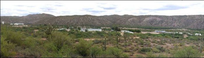
View of the headquarters.
Climate and Precipitation
Climatic data recorded from 1908 to 2008 in Wickenburg (elevation 2,070’ – elevation headquarters 2,300’) is as follows:
| Average January high |
64.5° |
| Average January low |
31.2° |
| Average July high |
103.6° |
| Average July low |
69.5° |
| Average annual rainfall |
11.21” |
| Average annual snow |
0.2” |
The fall, winter and spring months in the Wickenburg area are typically mild and are the envy of most Midwest and East Coast states in the U.S. This is a great area to get out of the snow and cold.
Comments
The Hassayampa River Ranch allows an owner to operate a small ranch in a very scenic and private setting that is not too far from Wickenburg. Wickenburg, once called the “dude ranch capital of the world” is the oldest town north of Tucson. It dates to 1863 when Henry Wickenburg discovered the Vulture Mine, the richest gold-producing mine in Arizona’s history. The historic town has a population of over 6,400 and offers a relaxing western lifestyle with a full range of services. With the amount of building improvements, there are many options that a new owner has with the ranch. Also, the Hassayamapa River provides for excellent shallow water with an unlimited pumping supply.
Price
$2,000,000 Cash. The ranch is shown by appointment only.
Printable Brochure
 Please
click here to download (about 700kb) a
printable brochure in Adobe Acrobat format. If you get frustrated
trying to make this work on your computer, don't hesitate to ask us
to mail you a printed and bound brochure instead.
Please
click here to download (about 700kb) a
printable brochure in Adobe Acrobat format. If you get frustrated
trying to make this work on your computer, don't hesitate to ask us
to mail you a printed and bound brochure instead.
Contact
Offered for sale exclusively by:
Paul Groseta
Headquarters West, Ltd.
51 Verde Heights Drive, Suite A
P.O. Box 1840
Cottonwood, AZ 86326
Phone: (928) 634-8110; Fax (928) 634-2113; Cell (928) 853-8369
Email: paul@headquarterswest.com
Web: www.headquarterswest.com/hrr