***
OFF THE MARKET ***
Coyote Creek
Apache County, Arizona
Pictures
Please
click on any of the pictures for a larger view
Location & Maps
Please click on any of the maps
for a larger view
|
|
|
|
|
|
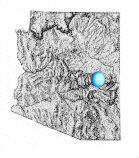
General
location in Arizona
|
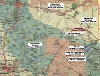
Location
map
|
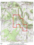
Topographic
Map
|
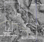
Aerial
image
|
Location
The property is located in eastern Arizona near the New Mexico state
line in southern Apache County approximately 200 miles northeast
of Phoenix, Arizona and 170 miles southwest of Albuquerque, New
Mexico. The property is situated ½ mile south of US Hwy 60
along Coyote Creek and 11 miles east of Springerville, near the
White Mountains of Arizona. The property is accessible by 8 miles
of paved US Hwy 60 east from Springerville, Arizona to County road
#4225 (maintained gravel), then 3½ miles southeast on #4225
to a dirt road, then 2 miles east to the boundary.
Land Tenure
504 deeded acres – vacant unimproved
Legal Description
Township 9 North Range 31 East
Gila and Salt River Baseline and Meridian
Sections 27, 28 & 34: Portions thereof
Apache County Assessor parcel numbers: 105-38-001, 105-39-001 &
105-41-001
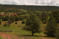
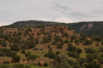
Property Description
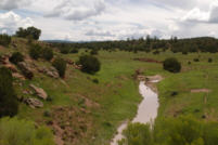
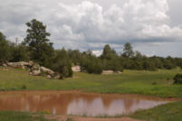
The land is contained in an irregular block along Coyote Creek.
The creek is a dry wash and only runs during periods of heavy rain
or significant snow melt in the spring time. The deeded land is
completely surrounded by State Trust land in Arizona and neighbors
the Escudilla Bonita subdivision across the state line in New Mexico.
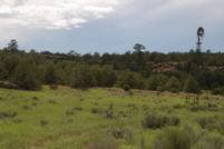
There are no building improvements located on the property. Topography
includes rolling hills with scattered Pinion Pine and Juniper trees,
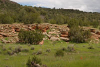
overlooking the Coyote Creek arroyo. The arroyo and hillsides are
made up of red and tan sandstone formations with many large boulders
scattered among the trees. A large malpais mesa lays along the eastern
boundary of the property providing a private atmosphere.
Water
There is no developed water on the property, however; wells in the
area vary between 100 and 400 feet deep with domestic drinking water
quality.
Vegetation
Plains & Desert Grassland, Pinion/Juniper Woodland and Montian-Conifer
Forest. Primary grasses include Kentucky bluegrass, pine drop seed
and mountain muhly on the summer range and blue grama, black grama,
squirrel tail, needle & thread on the winter range. Browse species
include white sage, blue sage and chamisa.
Climate
Average annual precipitation ranges from 10 to 12 inches with the
majority coming in the late summer months during the monsoon season.
Winter months will see snowfall on occasion typically melting down
after a few days.
|
§
|
Mean
Min
|
Mean
Max
|
| January |
51.1º
|
82.3º
|
| July |
15.2º
|
47.5º
|