Location
& Maps
Please click on any of the maps
for a larger view
|
|
|
|
|
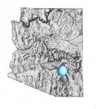
Location
within Arizona
|
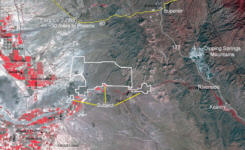
Satellite
image
|
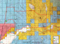
Tenure
map
|
The
Ranch is located in the rural area of northern Pinal County, approximately
2 to 14 miles northeast of the Town of Florence, Arizona.
Site Data
The Ranch is an irregular shaped parcel, averaging three to six miles
deep north to south, by eleven miles wide east to west, and embraces
29,330.75± acres of land. This gross acreage is comprised of the following
land uses:
-
Parcel
1 - Deeded Lands: 40± acres, located at Twin Tanks off of Hwy 79.
-
Parcel 2 - State Leased Lands: 15,118.04± acres of AZ State Grazing
Leasehold
-
Parcel 3: - 12,570.86± acres of BLM grazing leasehold, embracing
two separate leases that are approximately Vt mile apart.
-
Parcel
4: - Private water access: 120 acres with a drinker at Bridgeport
on the Gila River, and 120 acres with a well and drinker at C Camp
on the Gila River.
Parcel 1 has a dirt stock tank and a set of shipping pens. Tract 1 is
bisected by a wash and has some minor flood hazards. Tract 3 (C Camp)
has a well and electric utilities, and the well has a pipeline running
north to a set of pens and drinker on the State lease.
Parcel 2, the State lands, are rated at a carrying capacity of 118.1±
head annually. Parcel 3, the BLM lands, are rated at a carrying capacity
of 116± head annually. Parcels 1,2 and 3 will give a total AUYL of 234.1.
The BLM and State have determined these adult cattle stocking rates.
There is some additional grazing on ephemeral feed when weather and
water permits. But these numbers vary from year to year in the length
of the ephemeral grazing period and the numbers of cattle stocked.
The main body of the Ranch has elevations varying from a high of approximately
1,500 to 1,700 feet along the west boundary of the ranch along AZ 79,
to 2,500 and 3,000 feet on the mountains at the east end of the ranch.
The Cochran allotment portion of the Ranch is located at the old Cochran
siding on the Southern Pacific Railroad. There is one spring on this
portion of the ranch, which is % mile distant from the southeast corner
of the main body of the ranch. Elevations vary from a low of 1,625 feet
at the Railroad, to a high of 2,454 feet on a small mountain. This portion
of the ranch is 3 miles wide east to west by % to 2 miles deep north
to south. This portion of the property is not an economically sized
ranch unit on its own, but is close enough to the balance of the ranch
that it is operated as a separate pasture.
The Ranch is located in the desert-intermountain region of the state,
and the land forms are generalized as ranging from gently sloping to
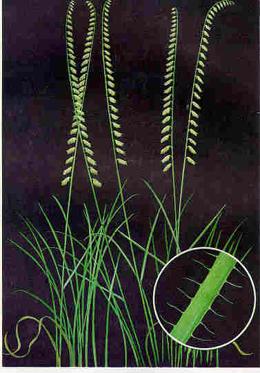
rolling to very rugged. The native range forages consists primarily
of black, blue
and side oats grama
grasses, big galleta,
sacaton, tobosa,
needle grass, squirreltail, Arizona
cotton-top, cane beardgrass, three
awn, panic grass, sprangle top and spike dropseed; forbs consist
of alfilaria, and Indian Wheat; shrubs consist of guajilla, palo
verde, bush muhly, range ratany and mesquite.
Non-forage plants consist of ocotillo,
saguaro, cholla, ironwood
and creosote.
The main body of the ranch is fenced into two traps and one large pasture,
plus the Cochran Allotment as a separate pasture. Ranch exterior fences
are five strand barbed wire on metal and wood posts and are in fair
condition. Interior ranch fences are primarily four strand, and vary
from fair to poor condition. There are holding/sorting or shipping pens
on the leases and deeded lands, varying from fair to poor condition.
Livestock waters are reported to adequately serve the livestock, except
in drought years, or when there are large numbers of steers. There are
three large stock ponds on the west side of the ranch. There is three
working wells on the leases, all working wells have drinkers. There
are two registered springs, and live water is occasionally found in
Box Canyon on the east end of the ranch for portions of the year. Water
storage at the well sites consists of metal tanks. There may be the
need to haul water when stocker steer numbers are large.
Flood Hazards
Per the F.E.M.A. Flood Insurance Rate Map #040077, Panel #05250, Dated
8/15/83, portions of Parcel 1 are impacted by flood hazards by the wash
that feeds the large Twin Tanks, and this hazard is not fully delineated.
The Broker estimates that the area impacted by the Flood Zone A hazard
on Tract 1 is probably 10 acres of the Tracts 40 acres, or 25%.
Zoning
The Ranch is located in the unincorporated rural areas of Pinal County.
Zoning in such areas is controlled by the county. Per the Pinal County
Planning and Zoning Department, the Ranch's zoning is described as follows.
Subject Parcel No. 1 is held in fee simple, and legal and permitted
uses are those uses permitted by zoning. Current zoning of Parcel 1
is GR, General Rural, which permits for the construction of one single
family residence and agricultural uses on a minimum site of 1.25 acres.
Parcel 1 is also adjacent to the Arizona National Guard Gunnery Range,
and gunnery practice is conducted on the State lands at different times
of the year. The grazing leaseholds are public lands and are considered
to be un-zoned by the State and Federal agencies that administer those
lands.
Improvements
There are no building improvements on the Ranch parcels, but there are
livestock waters, shipping and holding pens, and fencing for the grazing
uses.
Price
$480,000
This new price reflects the owner's recent addition of a new set
of pens on the deeded lands, and the intention of adding a new livestock
well on the deeded land, and bringing in power from SR 79.
Terms
Cash
Printable
Brochure
 Please click here to download (about 500kb)
a printable brochure in Adobe Acrobat format. If you get frustrated
trying to make this work on your computer, don't hesitate to ask us
to mail you a printed and bound brochure instead.
Please click here to download (about 500kb)
a printable brochure in Adobe Acrobat format. If you get frustrated
trying to make this work on your computer, don't hesitate to ask us
to mail you a printed and bound brochure instead.
Disclaimer: This information was obtained
from sources deemed to be reliable but is not guaranteed by the Broker.
Prospective buyers should check all the facts to their satisfaction.
The property is subject to prior sale, price change, or withdrawal.
|
