*** SOLD ***
H Bar V
Apache County, Arizona
and
Catron County, New Mexico
Pictures
Please
click on any of the pictures for a larger view
|
|
|
|
|
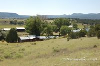
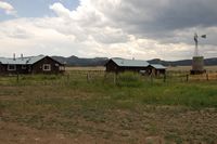
[1] Overview of the Headquarters Site |
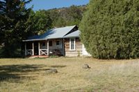
[2] Cabin at the Headquarters |
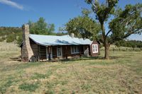
[3] Art Studio/Cabin |
|
|
|
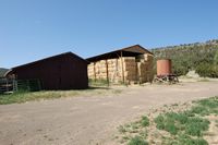
[4] Livestock and hay barns |
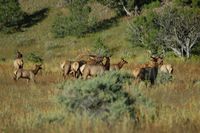
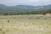
[5] Ranch Elk |
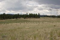
[6] Irrigated field |
|
|
|
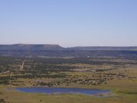
[7] Lake Marie |
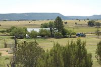
[8] Manager's house |
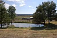
[9] Headquarters pond |
|
|
|
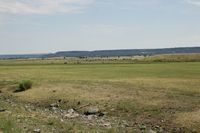
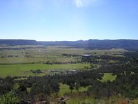
[10] Overview of Arizona deeded land |
[11] Deeded land at Bill Knight spring |
[12] Deeded land in Spur Lake Basin |
|
|
|
[13] Gribble place in Spur Lake Basin |
[14] Deeded land in Spur Lake Basin |
[15] Deeded land in Spur Lake Basin |
|
|
|
[16] Deeded land in Spur Lake Basin |
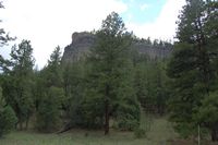
[17] Forest Allotment |
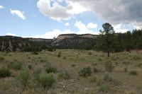
[18] Forest Allotment |
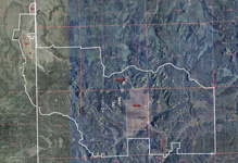
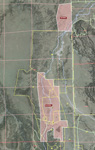
Location
& Maps
Please click on any of the maps
for a larger view
|
|
|
|
|
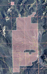 |
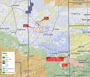
| Location
map |
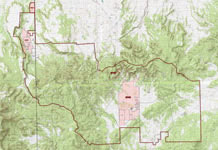
Topo
Map* |
Aerial Map* |
AZ deeded* |
NM deeded* |
* These are large files that will take a while to download; we're also happy to mail out large 24x36 prints of either of these maps on request
Property Identification
The H-V Ranch consists of approximately 5,876 acres of deeded land in Arizona and New Mexico with an additional 80,751 acres National Forest leas land in the Quemado Ranger District of the Gila National Forest. The ranch headquarters is located on approximately 1,392 deeded acres in Arizona along Coyote Creek. Building improvements at the main headquarters site include a manager’s house, five cabins, three hay barns and numerous out buildings. There is also a full set of working corrals at the headquarters. There is approximately 360 acres of irrigated farm land along Coyote Creek, irrigated with diversionary and storage rights on Coyote Creek. H-V Reservoir and Lake Marie are used as the storage reservoirs for the irrigation water. Recently, only 120 acres have been farmed due to drought and lack of available irrigation water. The Gribble Cow Camp is located on approximately 4,445 deeded acres in the Spur Lake Basin in New Mexico, near the east central portion of the ranch. Building improvements consist of a cowboy cabin/house, a bunkhouse, large hay shed, several outbuildings and a complete set of working corrals. Bill Knight Spring contains the remaining 40-acres of deeded land and is located just off Forest Road 19, one mile before coming to Spur Lake Basin. The ranch is located on both sides of the Arizona/New Mexico state line. The majority of the grazing allotment and the Gribble Place is located in New Mexico within the boundary of the Apache National Forest. The property is operated as a single unit and utilized for cattle grazing. Topography and vegetation varies significantly throughout the ranch from open rolling grassland to scattered pinion/juniper woodlands, to high mountain elevations with ponderosa, conifer and aspen trees.
Location and Access
The ranch is located along the Arizona/New Mexico state line approximately 15 miles southeast of Springerville, Arizona and 35 miles southwest of Quemado, New Mexico. US Highway 60 provides access to Apache County Road #4225, then southeast 8 miles to the ranch boundary and the headquarters site along Coyote Creek. The ranch stretches to the east into Catron County, New Mexico, approximately 20 miles to the eastern boundary. Access to the Gribble Place is provided by forest road #205 from the headquarters. Interior access is provided by numerous forest county roads.
Physical Characteristics
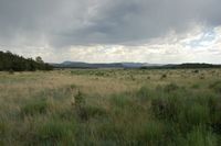
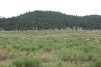
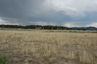
The Arizona deeded property lies along Coyote Creek and varies from thickly treed hillsides to open meadow land. Primary tree cover consists of Pinion/Juniper Woodlands with scattered Ponderosa Pines on the mesas surrounding the valley. Coyote Creek meanders from south to north through the deeded lands and immediately adjacent to the headquarters buildings. Numerous clumps of Oak trees surround the buildings and irrigated fields. Elevation ranges from 7,300 to 7,800 feet across the property. The New Mexico deeded property lies primarily in the Spur Lake Basin and is completely surrounded by National Forest property. The Spur Lake property is primarily open grassland surrounded by thickly covered hillsides. Tree cover consists of Ponderosa Pines and Oak. Approximately 40 acres is non-contiguous to the Spur Lake property and is located at the bottom of the hill under Bill Knight Gap and just above Bill Knight Spring. This 40 acre parcel is very private and secluded with many large Oak and Ponderosa Pines. Bill Knight Spring has been developed for livestock watering use. Elevation on the Spur Lake parcel ranges from 7,380 to 7,800 feet and the Bill Knight parcel ranges from 7,800 to 8,000 feet. Vegetation on the property is classified as short grass (plains) grassland. Primary grasses are blue grama, black grama, needle-and-thread, muhlys, sand dropseed, and galleta. The majority of the area is pinion/juniper woodland with many “old growth” type trees. The higher elevations also have ponderosa pine, conifer and aspen trees with pine drop seed, kentucky blue grass and mountain muhly grasses.
Building Improvements
The main building improvements are located on the deeded lands in Arizona along Coyote Creek and are listed as follows:
-
Managers Home: 2,012 square feet of wood and rock construction, metal tin roof, 4 bedrooms, 2 bathrooms with a rock fireplace and forced air for heating.
-
Cabin #1/Art Studio: 1,111 square feet, old log and wood construction with wood floor, fireplace, 1 bedroom, 1 bathroom and a metal tin roof.
-
Cabin #2: 816 square feet, old log and wood construction with wood floor, fireplace, 1 bedroom, 1 bathroom and a metal tin roof.
-
Cabins #3, 4 & 5: total 1,520 square feet and are connected by a covered porch and walkway. They are all old log and wood construction with wood floors, fireplace, 1 bedroom, 1 bathroom each and a metal tin roof. Cabin #5 is unfinished inside and currently used as a tack room.
-
Hay Shed: 1,792 square feet, wood frame construction (telephone pole) with metal tin roof, dirt floor and open walls.
-
Hay Storage/Horse Stalls: 930 square feet, wood frame construction with metal tin roof, dirt floors and attached horse corrals.
-
Log Hay Barn: 960 square feet, log and wood construction with metal tin roof, dirt floors and attached horse corrals.
-
Horse Shade: 883 square feet, telephone pole construction with wood framing, metal tin roof and dirt floor with attached corrals.
-
Tack Shed: 380 square feet, wood construction, metal tin roof and wood floor.
-
Generator House: 240 square feet, wood frame construction, metal tin roof and concrete flooring.
-
Shop/Storage Shed: 2,400 square feet, wood frame and telephone pole construction, metal tin roof with partial concrete and dirt flooring.
-
Wood Shed: 196 square feet, wood frame construction, metal roof and dirt floor.
The Gribble Place is primarily used as a cow camp on the eastern end of the ranch. The buildings are located in the central portion of the Spur Lake Basin with primarily open grasslands surrounded by high mesas. Building at the camp include the following:
-
House: 1,162 square feet, wood frame construction, metal tin roof and wooden floors with a small screened in porch in the back of the house.
-
Bunkhouse: 476 square feet, wood frame construction, metal tin roof and wooden floors.
-
Feed Shed: 520 square feet, wood frame construction, metal tin roof and concrete floor.
-
Generator House: 80 square feet, wood frame construction, metal tin roof and concrete floor.
-
Hay Shed: 1,344 square feet, telephone pole construction, open walls, metal tin roof and dirt floor.
-
Tack/Stalls/Hay Shed: 1,880 square feet, wood frame construction, wood siding, metal tin roof and dirt floors.
-
Calving Shed: 936 square feet, wood frame construction, wood siding three walls only, metal tin roof and dirt floors.
Soils
According to the U.S.D.A. Soil Conservation Service “Soil Survey, Apache County, Arizona and Catron County, New Mexico” the primary soils on the property are:
Tours-Jocity association:
Well-drained, deep, nearly level to gently sloping clay loams and sandy clay loams formed in alluvium.
Cabezon-Datil-Hubbell:
Shallow and deep, well drained, sloping to steep soils; mainly on mesas, hills, and alluvial fans.
Tolman-Smilo-Pleioville
Shallow and moderately deep, well drained, level to steep soils; on hills, mountains, alluvial fans, and plains.
Utilities
Telephone service is provided by Western New Mexico Telephone. No other public utilities are available to the ranch. Electricity is by private diesel generators, sewer service is provided by septic systems and propane is used for heating and cooking.
Water:
Arizona
Domestic water at the headquarters is provided by a private well with an electric submersible pump filling a 5,000 gallon water tank on a hill above the building site. The water then gravity feeds back to the houses and corrals for livestock water. Irrigation water is diverted from Coyote Creek into several dirt ditches and flooded across the fields. Water is also stored in two reservoirs, H-V Reservoir and Lake Marie. H-V Reservoir has a storage right for 541.8 acre feet per annum and Lake Marie has a storage right for 180 acre feet per annum for a total of 721.8 acre feet per annum of storage. The ranch has two registered water claims for use of 541.8 acre feet per annum and 320 acre feet per annum for a total of 861.8 acre feet per annum. These registered claims are for irrigation and livestock purposes on a total of 360 acres. Water is solely obtained from Coyote Creek and in dry years, there is not enough water in the creek to fully utilize the registered claims. Over the past five years, the ranch has only had enough water to irrigate approximately 120 acres due to drought and small flows of water in Coyote Creek.
New Mexico
Domestic water at the Gribble Place is supplied by a private well with an electric submersible pump filling an elevated storage tank that gravity feeds back to the house and corrals for livestock. There is approximately 120 acres of “dry land” farm which has not been utilized in many years. The ranch has simply used the property for livestock grazing. There are no known irrigation claims for this acreage. The deeded property in New Mexico has five separate water adjudications from the New Mexico State Engineers Office totaling 15 acre feet per year for livestock use only. There are no irrigation rights associated with the New Mexico deeded lands.
Range Livestock Water
There is approximately 38 miles of pipeline with numerous drinkers and storage tanks spread throughout the ranch. The pipelines are spring fed with pumping stations along the way. In addition to the pipeline there are several wells with windmills and numerous dirt tanks and springs scattered across the ranch. Overall the ranch contains adequate water to support the livestock and fully utilize the range.
Hunting
The portion of the ranch located in New Mexico has historically participated in the big game landowner hunting permit program administered through the New Mexico Game and Fish Department. Tag allocations vary from year to year depending on herd population and landowner willingness to participate. The past two seasons the ranch has received 4 bull elk – archery tags, 4 bull elk - muzzle loader tags and 5 cow elk– archery/muzzleloader tags.
Legal Description
Township 8 North, Range 31 East
Gila and Salt River Base Line & Meridian
Sections 11, 22, 23, 26, 27, 34 & 35: portions thereof
Township 9 Noth, Range 31 East
Gila and Salt River Base Line & Meridian
Section 2: portion thereof
Township 3 South, Range 20 West
New Mexico Principle Meridian
Sections 26, 35 & 36: portions thereof
Township 4 South, Range 20 West
New Mexico Principle Meridian
Sections 1, 2, 11, 12, 13, 14, 23, 24 & 26: portions thereof
Apache National Forest, Quemado Ranger District, Spur Lake Allotment
Taxes Parcel Numbers Tax Year 2008
County |
APN |
Acres |
Full Cash Value |
Taxes |
| Apache |
104-39-003 |
316.00 |
3,986.00 |
45.56 |
| Apache |
104-39-004A |
1,076.00 |
338,685.00 |
1,617.94 |
| Catron |
2633 |
4,484.38 |
34,905.00 |
137.09 |
| Total |
- |
5,876.38 |
377,576.00 |
1,800.59 |
Federal Grazing Fees
$1.35 per animal unit month for the year 2008
Land Tenure
Acres |
Tenure |
1,392 |
Deeded - Arizona |
4,485 |
Deeded - New Mexico |
80,751 |
USFS lease |
86,598 |
Total - or 135 sections |
Carrying Capacity
82 animal units deeded*
315-438 animal units from 3/01 to 5/31**
478-601 animal units from 6/01 to 10/31**
315-438 animal units from 11/01 to 2/28**
520 animal units yearlong equivalent
*carrying capacity based on 9 head per section
**for a total of 6,071 animal unit months (AUM)
Ranch Price
$7,200,000 – Cash
Printable
Brochure
 Please click here to download (about 3
MB) a printable brochure in Adobe Acrobat format. If you get frustrated
trying to make this work on your computer, don't hesitate to ask us
to mail you a printed and bound brochure instead.
Please click here to download (about 3
MB) a printable brochure in Adobe Acrobat format. If you get frustrated
trying to make this work on your computer, don't hesitate to ask us
to mail you a printed and bound brochure instead.
Contact
Offered
for sale exclusively by:
Traegen H. Knight
Headquarters West, Ltd.
PO BOX 1980
St. Johns, AZ 85936
Phone: (928) 524-3740, Fax: (928) 563-7004, Cell: (602) 228-3494
Email: info@headquarterswest.com
Web: www.headquarterswest.com/hbarv
See
Also
Also handled
by Traegen Knight in the area:
- Coyote Creek Development Parcel -316 acres of the H Bar V that is available separately
- Udall Ranch - 1,700 acres in Apache County
- Concho Ranch - 31,471 acres in Apache County
- Sold -
Goodwater Ranch
- 56,158 acres in Navajo County
- Sold - Greens
Peak Ranch
- 17,938 acres Apache County
Handled
by Con Englehorn:
- Sold
- Chevelon Canyon, 66,370 acres/728
AU in Navajo County
Disclaimer:
This information was obtained from sources deemed to be reliable but
is not guaranteed by the Broker. Prospective buyers should check all
the facts to their satisfaction. The property is subject to prior
sale, price change, or withdrawal.
Keywords - real
estate , land , property 85290 85925 85932 85927 85938 85940 85924
85936 86509 86502 near n s e w north south east west springerville
witch well concho floy eagar nutrioso alpine beaverhead |