*** OFF THE MARKET ***
96
Ranch
Pinal County
Pictures
Please
click on any of the pictures for a larger view
|
|
|
|
|
[1]
Granite boulder outcroppings on the deeded land
|
[2]
Uniquely placed boulder in the granite outcroppings on the deeded
land
|
[3]
More granite boulder outcroppings and saguaro cactus on the
deeded land
|
|
|
|
|
|
[4]
View overlooking the west end of the ranch from the highest
point on the deeded land
|
[5]
View of the headquarters below from the highest point on the
deeded land
|
[6]
Looking southwest near the northern boundary of the deeded land
|
|
|
|
|
|
[7]
View of the east end of the ranch from the highest point on
the deeded land
|
[8]
Shipping pens near the western boundary of the deeded, looking
east towards the deeded land
|
[9]
View of the barn and other outbuildings at the headquarters
on the deeded land
|
|
|
|
|
|
[10]
Hackberry Tank on the east end of the grazing lease
|
[11]
More granite outcroppings on the grazing lease south of the
deeded land near Buck Tank
|
[12]
Rangeland south of the deeded land in the Ninetysix Hills
|
|
|
-
|
-
|
|
[13]
Rangeland with saguaros on the west end of the grazing lease
near the Middle Mountains
|
-
|
-
|
Location
& Maps
|
|
|
|
|
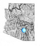
General
location in Arizona
|
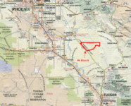
Location
map
|
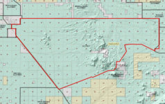
Tenure
Map *
|
|
*
This is a large maps and will take some time to load on slower
internet connections; we are also happy to send out large 24"
x 36" prints of these maps upon request.
|
Location
& Access
The 96 Ranch is centrally located in Pinal County, Arizona between
Phoenix and Tucson. Phoenix is approximately 75 driving miles to the
northwest and Tucson is approximately 50 driving miles to the southeast
of the ranch. Outlying metro areas such as Chandler and Oro Valley
are even closer. Florence, the Pinal County seat, is 15 miles to the
northwest.
Highway
79 borders the ranch for over eight miles and serves as the western
boundary. The deeded land on the 96 Ranch is eight miles east of Highway
79 on 96 Ranch Road, which is a good gravel road. Interior ranch access
is provided by numerous dirt roads that are of varying condition.
Description
The 96 Ranch spans over 88 square miles of Sonoran Desert. The west
end of the ranch, with the exception of the Middle Mountains, is relatively
level. The Ninetysix Hills divide the ranch running from the northern
to the southern boundary and consist of rolling to steep areas with
boulder outcroppings. The east end of the ranch is higher in elevation
than the west end and is more level to rolling. The west end produces
mainly annual feed, while the higher elevations in the hills and on
the east end of the ranch produce more perennial feed. Grasses on
the ranch consist of gramas,
lovegrasses, sand dropseed,
threeawns and annuals
such as filaree and indian
wheat. Trees and browse throughout the ranch include mesquite,
catclaw, palo
verde, jojoba and creosote.
Saguaro, yucca, cholla
and prickly pear cacti are also found throughout the ranch. Wildlife
found in the area include quail,
mule deer, a few whitetail
deer, javelina, coyotes,
coatimundi and mountain
lion.
The
deeded land on the 96 Ranch is roughly in the center of the state
lease and is nearly the highest point on the ranch. The Ninetysix
Hills provide an enchanting setting for the deeded land with granite
boulder outcroppings and saguaro cacti. Views are exceptional in every
direction on the deeded land, from the Picacho Mountains and the towns
of Coolidge and Florence to the west to the Tortilla and Galiuro Mountains
to the east, and from the Superstition Mountains to the north to Black
Mountain and the Santa Catalina Mountains to the south.
Acreage
|
642.093±
|
Deeded
Acres |
|
56,284.46±
|
State
Grazing Lease Acres |
|
56,926.55±
|
Total
Acres, or 88.95 sections |
Carrying Capacity, Corrals & Fencing
The state grazing lease is for 529.8 AU yearlong. Including the deeded
land, total yearlong capacity is estimated to be 535 AU. During wet
years, the west end of the ranch produces tremendous amounts of annual
feed allowing for considerable excess seasonal grazing.
The
ranch is perimeter fenced and has eight pastures and two smaller traps.
Nearly every water has a set of corrals used to handle small sets
of cattle. The sucker rod shipping pens are located on the state lease
near the west end of the deeded land. Some of the fences and corrals
need some work as some maintenance has been deferred over the last
decade.
Water
The ranch is watered via 17 earthen tanks and drinkers distributed
via pipelines from wells. The earthen tanks are reliant on surface
runoff to fill. The wells are not equipped and the pipelines do need
work. The deeded land is located in both the Pinal and Tucson AMA's.
Weather,
Precipitation & Elevation
Weather records from Florence show:
|
-
|
Min
|
Max
|
| January |
37.3º
|
66.4º
|
| July |
74.9º
|
105.5º
|
Yearly average of precipitation at Florence is 10".
Florence is 15 miles away and is located at 1,500' but is the closest
weather station to the ranch.
The
ranch ranges in elevation from 2,000' at the west end of the grazing
lease to 3,800' in the Ninetysix Hills near the deeded land. The deeded
land ranges in elevation from 2,790' on the west end to 3,480' on
the east end.
Building
Improvements
The building improvements are minimal and uninhabitable at the headquarters.
The building improvements consist of a 1,650 s.f. adobe house built
in 1936, a 960 s.f. barn with a set of sucker rod corrals and pens
for horses and other various outbuildings. The wells and water cistern
are not operable and the condition of the septic tank on the residence
is unknown.
Utilities
There are no utilities to the ranch. Historically, a generator and
solar system has provided electricity, however, the generator and
solar systems are no longer operating. The two wells on the deeded
land are powered via electric submersibles. Sewer is by septic, propane
is by private carrier, and telephone is by cellular. Electric and
telephone lines parallel Highway 79.
Taxes
& Grazing Fees
| 2006
property taxes |
$965.74
|
-
|
| 2007
State Grazing Lease Fees |
$15,258.24
|
$2.40
per AUM
|
| Total
property taxes and grazing fees |
$16,223.98
|
-
|
Zoning & Flood Plain
The deeded land on the 96 Ranch is currently zoned GR by Pinal County,
1.25 acre minimum lot size.
The
deeded land is located on FEMA flood map 040077 1000C, with an effective
date of August 15, 1983. A small portion of the west end of the deeded
land is located in Zone A, areas of 100 year flood. The remaining
portion of the deeded land is located in Zone C, areas of minimal
flooding.
Comments
Less than a quarter of Pinal County is private property and the proximity
of the expanding Phoenix and Tucson metropolitan areas make the 96
Ranch a close escape with the potential for appreciation. Though the
ranching improvements do need some work, the 96 offers a blank canvas
for your own touches. The 96 would make an excellent guest ranch,
retreat or rural residence that offers the best of both worlds-peace
and escape from the fast pace of city life but close proximity to
the conveniences and amenities a city has to offer.
Price
The 96 Ranch is offered for sale "as is" at $4,500,000,
or approximately $7,008 per deeded acre
Reduced from $4,800,000 ($7,464 per deeded acre)
Terms
Cash, please submit all offers.

%20Granite%20boulder%20outcroppings%20on%20the%20deeded%20land.small.JPG)
%20Uniquely%20placed%20boulder%20in%20the%20granite%20outcroppings%20on%20the%20deeded%20land.small.JPG)
%20More%20granite%20boulder%20outcroppings%20and%20saguaro%20cactus%20on%20the%20deeded%20land.small.JPG)
%20View%20overlooking%20the%20west%20end%20of%20the%20ranch%20from%20the%20highest%20point%20on%20the%20deeded%20land.small.JPG)
%20View%20of%20the%20headquarters%20below%20from%20the%20highest%20point%20on%20the%20deeded%20land.small.JPG)
%20Looking%20southwest%20near%20the%20northern%20boundary%20of%20the%20deeded%20land.small.JPG)
%20View%20of%20the%20east%20end%20of%20the%20ranch%20from%20the%20highest%20point%20on%20the%20deeded%20land.small.JPG)
%20Shipping%20pens%20near%20the%20western%20boundary%20of%20the%20deeded,%20looking%20east%20towards%20the%20deeded%20land.small.JPG)
%20View%20of%20the%20barn%20and%20other%20outbuildings%20at%20the%20headquarters%20on%20the%20deeded%20land.small.JPG)
%20Hackberry%20Tank%20on%20the%20east%20end%20of%20the%20grazing%20lease.small.JPG)
%20More%20granite%20outcroppings%20on%20the%20grazing%20lease%20south%20of%20the%20deeded%20land%20near%20Buck%20Tank.small.JPG)
%20Rangeland%20south%20of%20the%20deeded%20land%20in%20the%20Ninetysix%20Hills.small.JPG)
%20Rangeland%20with%20saguaros%20on%20the%20west%20end%20of%20the%20grazing%20lease%20near%20the%20Middle%20Mountains.small.JPG)