*** OFF THE MARKET ***
Ortega Lake Ranch
Apache County, Arizona
Pictures
Please
click on any of the pictures for a larger view
|
|
|
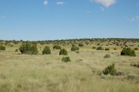
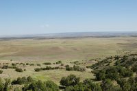
[1]
View looking S from HWY 61 |
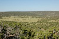
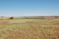
[2]
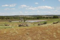
View looking N over Round Valley |
[3]
Round Valley well |
|
|
|
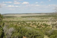
[4]
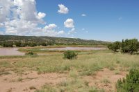
Overview looking W with dirt tank in distance |
[5]
Dirt tank |
[6]
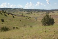
Typical rangeland |
|
|
|
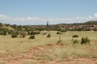
[7]
Typical rangeland |
[8]
Dirt tank |
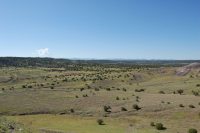
[9]
Northern portion of the ranch looking from Mormon hill |
|
|
|
[10]
Dirt tank |
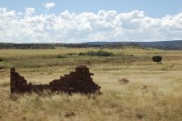
[11]
Mail Station Draw near the N boundary |
[12]
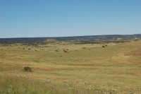
Typical rangeland |
 |
- |
- |
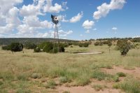
[13]
Windmill in the central part of the ranch |
- |
- |
Location
& Maps
Please click on any of the maps
for a larger view
|
|
|
|
|
|
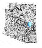
General
location in Arizona
|
Location
map
|
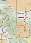
Topo
Map
|
Aerial
map
|
Location
& Access
The ranch is located in west central Apache County approximately 20
miles east of Show Low and 15 miles west of St. Johns, Arizona and
immediately west of Concho Valley. State Highway 61 runs through the
ranch from west to east with approximately two thirds of the ranch
north of the highway and one third south of the highway. The majority
of the deeded land is contained in two primary blocks, both being
south of Highway 61 at Laguna Salado and Mineral Creek. The Laguna
Salado block contains 320 acres and is directly south of Highway 61
on the western boundary of the ranch. The Mineral Creek parcel contains
174 acres and is located south of Highway 61 approximately 8 miles
along Mineral Creek. There are numerous county, private and ranch
roads providing vehicle access throughout the ranch.
Land
Tenure
|
Acres
|
Tenure
|
|
288
|
Deeded |
|
320
|
BLM |
|
18,666
|
State
Lease |
|
25,000
|
Open
Ranch Grazing (approximate) |
|
44,274
|
Total
(69 sections) |
Arizona State Lease #05-223
Bureau of Land Management Lease #6028
Taxes & Fees
Property taxes are $1,018 per year, AZ State Lease fees are $2.40/AUM and BLM fees are $1.35/AUM.
Legal
Description
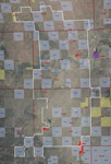
The ranch is located in Townships 11, 12 & 13 North Range 24 &
25 East, Gila and Salt River Baseline and Meridian with the deeded
parcels scattered throughout the ranch located at the primary watering
locations. The state lease lands are contained primarily in a checker-board
pattern with the open range, subdivision grazing lands.
Apache County Assessor parcel numbers and acreage:
|
APN
|
Acres
|
|
106-36-002
|
95.00
|
|
107-14-001F
|
54.42
|
|
107-14-001L
|
3.13
|
|
107-14-001N
|
74.92
|
|
107-64-100
|
0.90
|
|
107-64-101
|
1.03
|
|
107-67-102
|
2.33
|
|
201-08-008C
|
1.97
|
|
201-08-008D
|
2.07
|
|
201-60-077
|
38.96
|
|
201-74-098
|
6.22
|
|
201-74-099
|
5.98
|
|
201-08-009A
|
1.93
|
| Total
|
288.86
|
Carrying Capacity
|
AU
|
Tenure
|
|
4
|
deeded* |
|
262
|
State
lease |
|
5
|
BLM |
|
329
|
Open
range grazing* |
|
600
|
AU
yearlong |
*deeded and open range grazing capacities
are based on the State recommended stocking rate of 9 head per section.
Property
Description
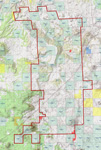
The ranch is contained in one primary block being 14 miles from north
to south and 7 miles from east to west at the widest points. The ranch
is more or less rectangle with State Highway 61 crossing through the
central portion from west to east. Range improvements are typical
with perimeter fencing and interior cross-fencing into four primary
pastures. There are no building improvements on the ranch and no permanent
shipping corrals.
Elevation ranges from 5,700' in Mail Station Draw near the north boundary
to 7,000' near the south boundary on top of Smooth Knoll. Vegetation
is Plains & Desert Grassland with Pinion/Juniper woodlands intermixed.
Rainfall averages 17.2" per year at Show Low and 11.2" per
year at St. Johns.
Area
Description
The ranch is located in eastern Arizona on the north facing slope
of the Mogollon Rim 20 miles northeast of the Show Low/Pinetop area
and just north of the Apache-Sitgreaves National Forest containing
the White Mountains of Arizona. The Show Low area and the Apache-Sitgreaves
National Forest is known for its many large
ponderosa pines, large herds of elk
and close proximity to numerous streams and lakes for trout fishing.
The mountains are popular for many outdoor activities such as hiking,
hunting, biking and camping. Also nearby is the Sunrise Ski Area on
the White Mountain Apache Indian Reservation located less than an
hours drive to the south. Sunrise has three downhill ski mountains
with trails for all levels of experience. Honda Resort and Casino
is also located on the Apache Indian Reservation just outside Pinetop
approximately a 30 minute drive from the ranch. Honda Resort and Casino
has a full casino, resort hotel, dining, entertainment and conference
center.
Water
Livestock water is provided by eight wells, 19 stock ponds, one spring and Mineral Creek. Mineral Creek is a seasonal creek and typically only runs during the rainy season and during the spring from the winter snow runoff. Many of the ranch windmills have been rebuilt in the past two years. Two of the wells have submersible pumps run by generator. Well production ranges from 2-10gpm.
Soils
Rudd association: Well drained, shallow and very shallow, undulating
gravelly loams and very stony loams formed in residuum from basalt.
Moenkopie-Sandstone rock land association: Well-drained, shallow
and very shallow, nearly level to moderately sloping loamy sands formed
in residuum from sandstone, and sandstone rock outcrops.
Tours-Jocity association: Well-drained, deep, nearly level
to gently sloping clay loams and sandy clay loams formed in alluvium.
Flood
Zone
Zone C, areas of minimal flood hazard except natural drainage areas
which are Zone A, areas of 100-year flood hazard.
Price
$1,100,000
Terms
Cash
Printable
Brochure
 Please click here to download (about 3
MB) a printable brochure in Adobe Acrobat format. If you get frustrated
trying to make this work on your computer, don't hesitate to ask us
to mail you a printed and bound brochure instead.
Please click here to download (about 3
MB) a printable brochure in Adobe Acrobat format. If you get frustrated
trying to make this work on your computer, don't hesitate to ask us
to mail you a printed and bound brochure instead.
Contact
Offered
for sale exclusively by:
Traegen H. Knight
Headquarters West, Ltd.
PO BOX 1980
St. Johns, AZ 85936
Phone: (928) 524-3740, Fax: (928) 563-7004, Cell: (602) 228-3494
Email: info@headquarterswest.com
Web: www.headquarterswest.com/ortegalake
See
Also
Also handled
by Traegen Knight in the area:
- Sold -
Goodwater Ranch
- 56,158 acres in Navajo County
- Sold - Greens
Peak Ranch
- 17,938 acres Apache County
Handled
by Con Englehorn:
- Sold
- Chevelon Canyon, 66,370 acres/728
AU in Navajo County
Disclaimer:
This information was obtained from sources deemed to be reliable but
is not guaranteed by the Broker. Prospective buyers should check all
the facts to their satisfaction. The property is subject to prior
sale, price change, or withdrawal.
Keywords - real
estate , land , property 85290 85925 85932 85927 85938 85940 85924
85936 86509 86502 near n s e w north south east west springerville
witch well concho floy eagar nutrioso alpine beaverhead